City, Map, Text: Postcolonial Surface Reading in Bleu blanc vert
Introduction: Why Map a Novel?
Maïssa Bey’s 2006 novel Bleu blanc vert is an account of two young people, Ali and Lilas, in Algiers from 1962 to 1992, revolving around their lives in one apartment building in the Belouizdad (formerly Belcourt) area. It is inherently spatial: the events of the plot are inseparable from the space in which they occur, be that space public or private. Bey peppers the narration of both of her two main characters with references to real places, both historical and contemporary, throughout the city. Sometimes the names are specific, sometimes general; sometimes the places are still locatable today, sometimes not. What’s more, some places that are central to the novel are not given a real-life referent, such as the very apartment building where the majority of the novel takes place. What patterns underlie the use of place names in the novel, and what do they reveal about Ali’s and Lilas’s relationships to space and to postcolonial Algiers? These questions form the basis of my mapping project of Bleu blanc vert. In this project, I will use several different maps of the novel to argue that its use of space reflects not only the main characters’ gendered relationship with space, but also with history and with the city itself.
A novel and a map could seem at first glance to have little in common. One is fictional, whereas one is presented as being “real”; one is usually made up of words, another usually of images; et cetera. Nonetheless, the two can and have been brought together. Franco Moretti argues that maps can serve as a tool for recognizing patterns that can then be analyzed (Moretti 53-54). For Moretti, these patterns, or “relations,” are the crucial point: “Locations as such did not seem that significant, if compared to the relations that the map had revealed among them… if I keep making diagrams, then, it is because for me geometry ‘signifies’ more than geography… It is a sign that something is at work here—that something has made the pattern the way it is” (55-56, emphasis in original). It would seem, then, that the maps or “diagrams” that Moretti makes are distinct from so-called “regular” maps, since in the latter, the geography, not the geometry, is what is significant. This, then, is one approach to mapping a novel. Another one can be found in the idea of “surface reading” put forth by Stephen Best and Sharon Marcus. They define the “surface” of a text as “what is evident, perceptible, apprehensible in texts; what is neither hidden nor hiding; what, in the geometrical sense, has length and breadth but no thickness, and therefore covers no depth. A surface is what insists on being looked at rather than what we must train ourselves to see through” (Best and Marcus 9, emphasis in original). Taken out of context in this way, this definition could just as easily apply to a map as to a text.
In the case of Bleu blanc vert, one of the things that might be said to be its surface, “what insists on being looked at,” is the city of Algiers. Unlike Best and Marcus’s definition, however, Algiers also “insists on being looked at…through” time. The novel gives the shifting landscape of postcolonial Algiers a central role, as place names change along with society, and tracks these changes across time. According to Henry Grabar, postcolonial Algiers can be thought of as a “palimpsest: the traces of history shine through even the most determined transformations. Each of the major efforts at appropriating French space remains tangled with colonial meaning, and validates the city as a complex and undervalued document of post-colonial national identity” (Grabar 391). Grabar’s use of the terms “palimpsest” and “document” to speak of primarily visual and spatial urban phenomena is revealing: the spaces of the city can be read like a text. In other words, when it comes to Algiers and Bleu blanc vert, the “surface” and the “depth” are one and the same (Best and Marcus 9). The consequence of this context is that my project of mapping the locations mentioned in Bleu blanc vert, while in one sense an attempt at surface reading and mapping, is in another sense a deeply close reading. The maps reveal how Ali and Lilas experience public space differently over the course of their lives, making for a curious kind of split bildungsroman and revealing the effects of gender on Lilas’s relationship with space, and vice versa, as a young woman. If we read the use of real places in the novel as a foregrounding of history, the maps illustrate not only Lilas’s and Ali’s different movements as a young woman and a young man, but also their different relationships with history and Algiers itself. To demonstrate this, I will first discuss what the maps of the novel reveal about the role of gender as a mediator with public space in the context of the coming-of-age story and then move on to discuss how the novel emphasizes the ways in which the map and the text are like each other.
Map Information
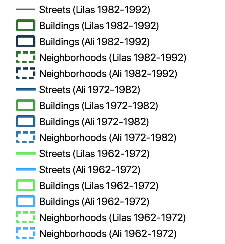
All base maps © OpenStreetMap contributors. Base map and data from OpenStreetMap and OpenStreetMap Foundation.
Projection: Voirol 1879/Nord Algerie (ancienne), EPSG: 30493.
A Gendered Bildungsroman
Bleu blanc vert tells both Ali’s and Lilas’s stories as they grow up over the course of thirty years. Beginning as young children and ending when they are married adults with a daughter of their own, and told in alternating chapters from each of their points of view, the novel has in this sense a very traditional structure: that of the coming-of-age story or bildungsroman. In this section, I will compare maps of the places that Ali and Lilas mention in each part of the novel. Each part spans ten years, with the first stretching from 1962 to 1972, the second from 1972 to 1982, and the third from 1982 to 1992.
Maps 1 and 2 show the locations mentioned by Ali and Lilas in Part One, and though they broadly share a concentration in the central areas of Algiers, they also differ from each other in several ways.
Part 1: 1962-1972
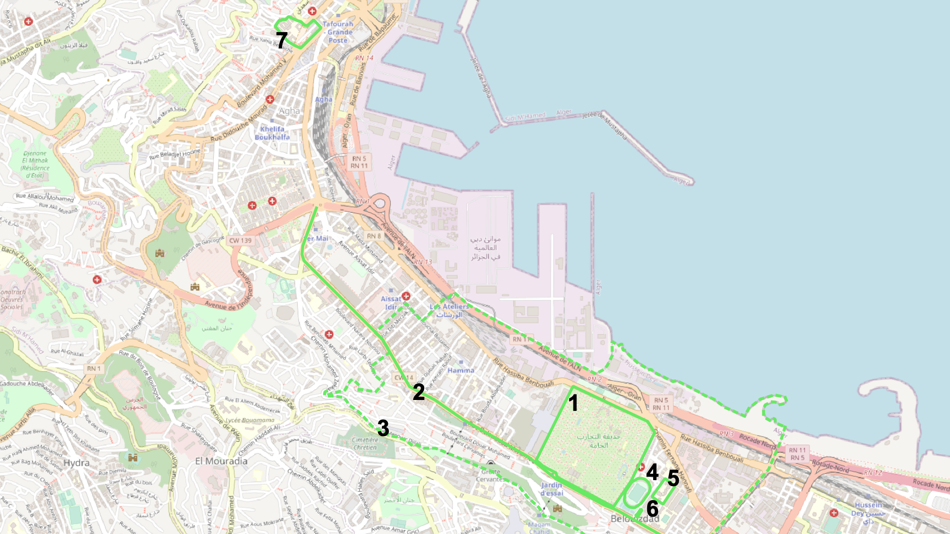
Map 1: Lilas in Part One
- Le Jardin d’Essai
- Rue Belouizdad/Rue de Lyon
- Belouizdad/Belcourt
- Stade du 20 Août 1955/Stade du Ruisseau
- Lycée Fodhil El Ouartilani
- Mairie de Belouizdad
- La faculté centrale
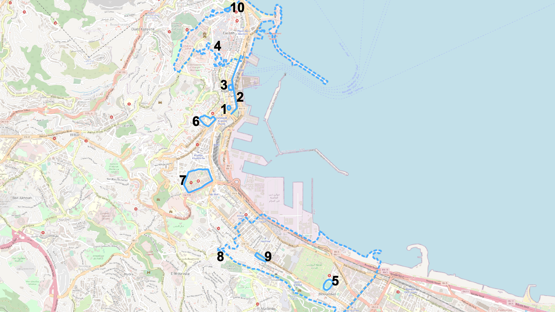
Map 2: Ali in Part One
- La Grande Poste
- Boulevard Zighout Youcef
- Assemblée Populaire Nationale
- La Casbah
- Stade du 20 Août 1955/Stade du Ruisseau
- La faculté centrale
- L’hôpital Mustapha
- Belouizdad/Belcourt
- Cimetière Sidi M’hamed
- Mausolée Sidi Abderrahmane
Both Ali and Lilas spend the years from 1962 to 1972 in the neighborhood of Belouizdad and their apartment building in it. This trend fits well into the traditional idea of a coming-of-age story: as children and young adults, they stay close to home before growing up and venturing out into the wider world. However, even in this early period, the maps of the places they mention show a difference in geographic range: Ali’s map includes a wider range of places, either visited himself (as in the protest that marched from “la Grande Poste” to the Assemblée Populaire Nationale (Bey 31)) or only mentioned (“la Casbah,” the area where, Ali learns, his older brother has visited “les filles” (51)). Politics appears in Lilas’s map as well, but reflected in a more subtle way; instead of a protest in front of a government building, we learn about how the events of the war, finished just before the start of the novel, affected Lilas’s family, specifically the places where they were and were not able to live: “Et c’est une femme qui vivait seule dans un quartier arabe qui est venue habiter dans notre appartement. On nous a échangés contre elle. Arabes contre Français. C’était une Française… Et pendant tout ce temps, on a habité chez elle. Dans sa maison. Pendant deux mois. En plein milieu du quartier arabe, juste à côté du nôtre. On était séparés par le Jardin d’Essai. C’était la frontière… C’est là-bas que j’ai vu mon premier mort” (39). Although still a child, we see in this passage Lilas’s awareness of what is going on around her as well as a moment of loss of innocence: “C’est là-bas que j’ai vu mon premier mort.” Overall, while Ali’s map extends further than Lilas’s in the beginning of the novel, political events and domestic life intertwine for both of them during this period.
The most important place of the novel—the apartment building where Ali, Lilas, and their families live—does not appear on the map, either in this first section or at any point. Though both Ali and Lilas describe the building in seemingly specific terms, they do not provide enough information to pin it down on a map of the city. For example, we know from Ali that “On est au bâtiment A. Huitième étage” (18) and from Lilas that it is part of an apartment complex: “C’est que notre immeuble est grand. Douze étages pour les deux bâtiments, A et B, et six étages pour le C. Avec deux appartements à chaque palier et trois pour le C, ça fait beaucoup” (21). We further know from Lilas that the building is on the rue Belouizdad: “On a changé d’adresse. On a changé de maison. Mais on est toujours dans le même immeuble. Maintenant on habite dans l’appartement de madame Lill. Et ce n’est plus la même adresse puisque notre rue s’appelle maintenant rue Belouizdad. Avant c’était la rue de Lyon” (52). In this quotation, Lilas points out the many-layered nature of Algiers’s public space, as I will discuss further later on, but she also simultaneously locates and does not locate the apartment building in the city. This important place, the site of so many of the scenes of the novel, does not appear on the novel’s map. Franco Moretti admits that maps cannot work for everything in literature, calling such moments “un-mappable forms …and these setbacks, disappointing at first, are actually the sign of a method still in touch with reality: geography is a useful tool, yes, but does not explain everything” (Moretti 53, emphasis in original). Perhaps, then, the “un-mappable” nature of the apartment building reflects the fact that its specific location, as an essentially private space, is not very important in contrast to the locations of the public spaces mentioned elsewhere. The “reality” that cannot be explained by maps is that of private life.
In the novel’s second part, however, the maps reveal a vast difference between the spatial dimensions of Ali’s and Lilas’s sections. In a previous project, we discussed one of the ways in which the novel is divided along gender lines: Ali often comments on large, external political events, whereas Lilas more often comments on women’s lives (O’Neill, Grabowski, Chen 2-3). Each character’s respective map for the ten years from 1972 to 1982 reveals that this difference is, in this section of the novel, reflected spatially.
Part 2: 1972-1982
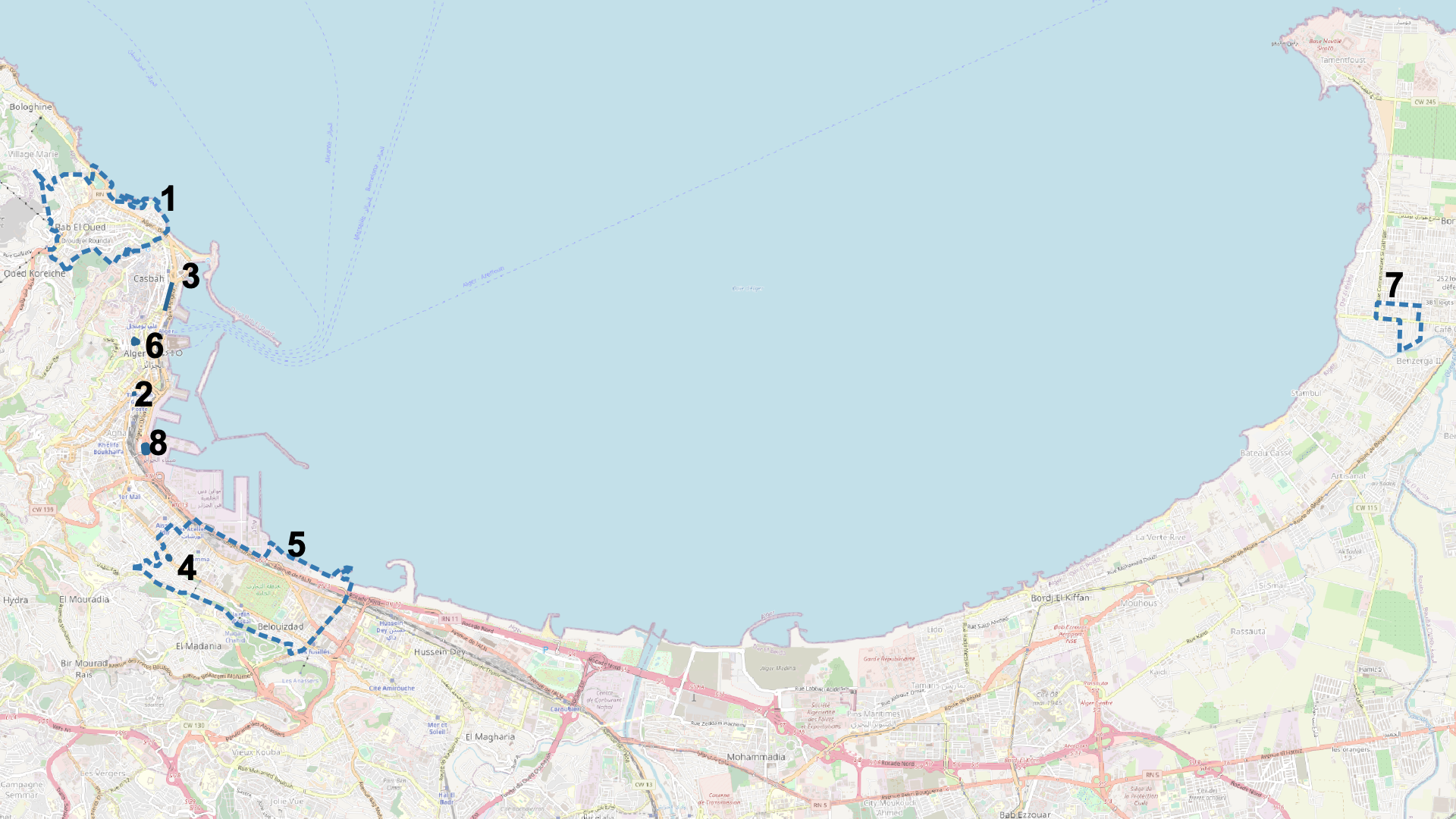
Map 3: Ali in Part Two
- Bab el Oued
- La Brasserie des Facultés
- Boulevard Ernesto Che Guevara
- Monoprix de Belcourt/Banque Extérieure d’Algérie (today)
- Belouizdad/Belcourt
- Galeries algériennes/Musée public national d’art moderne et contemporain d’Alger (today)
- Alger-Plage
- Champ de manœuvres
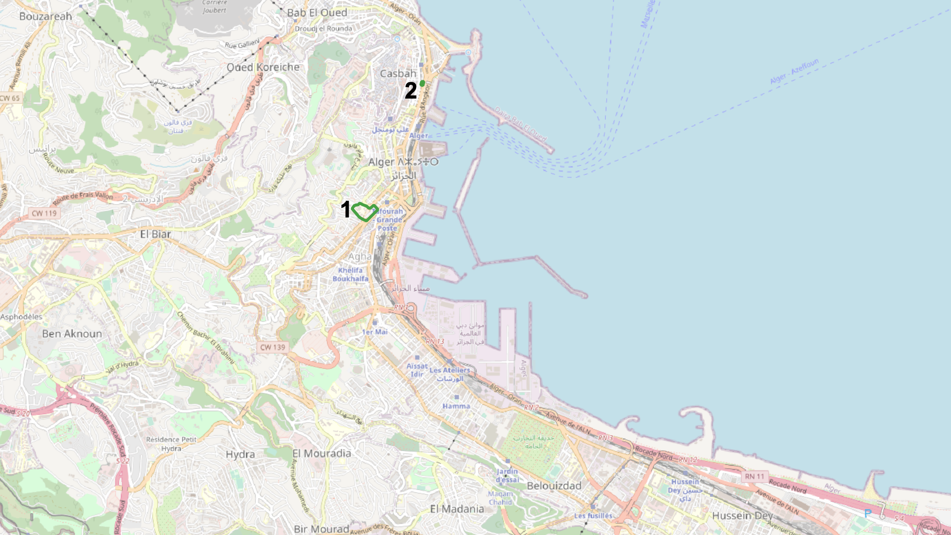
Map 4: Lilas in Part Two
- La faculté centrale (la faculté de sciences humaines)
- Conservatoire Central d’Alger
In this period, Ali’s map expands from his previous range, with mentioned neighborhoods stretching from Bab El Oued to Alger-Plage. The types of places that are mentioned are varied, but include his work as a lawyer (“l’immeuble de Bab El Oued où je me suis installé” (Bey 117)), a bus stop (“Champ de manœuvres” (136)), a café (“la brasserie des Facultés” (131)), a street (“un très grand boulevard” named after Che Guevara (132)), and an art museum (“Galeries algériennes de la rue Ben M’hidi” (133)). These places have one thing in common: they are all public rather than private. Politics in this public sphere reappears as well, as in the section where Ali comments on the global revolutionary politics that have come to be represented in Algiers’s streets and cafes: “Ainsi dans les rues d’Alger on croise, presque à chaque coin de rue, des hommes et des femmes venus d’ailleurs, de toutes les parties du monde, pour trouver refuge dans un pays qu’on dit être le phare du Tiers-Monde ou La Mecque de la Révolution… Prendre un café ou une bière à la brasserie des Facultés à la table voisine de celle de Kathleen et Eldridge Cleaver ne nous étonne même plus” (131). Ali’s life in Algiers continually bleeds into public, and often political, space.
In contrast, Lilas’s portion of this decade barely appears on the map at all. She still mentions some places (though significantly fewer than Ali does), but several prove to be impossible to map: the apartment building, for example, or the health center where she works, which is not given a name and only described as being “à quelques centaines de mètres de chez moi” (124). Lilas mentions only two places that I was able to pin down on the map: “la fac de sciences humaines,” where she studies and which we know from a previous Ali chapter is part of “la fac centrale” (124, 90) and the music conservatory where her brother Samir briefly enrolls (141). The result of this shift is that Lilas all but disappears from the map of Algiers after having started out on relatively equal footing with Ali. By showing visually how the more private or domestic spaces she tends to occupy in this section are not able to be mapped, the map both predicts and reflects the feelings of oppressiveness and suffocation she experiences in her marriage and her ultimate disappearance from public space into private during this section. This pattern is exemplified by the section’s final chapter, which begins “Il y a les sourires de mon enfant. Il y a les pleurs de mon enfant” and concludes “Il y a à présent, et pour tout présent, Alya, et rien d’autre. Rien d’autre? Non, rien d’autre, j’en suis sûre aujourd’hui” (181, 182). This chapter marks a tonal and stylistic shift from all of Lilas’s preceding chapters, which are more traditionally narrative, but the map reveals that this shift, rather than being a sudden breakdown, is instead a gradual process of withdrawal, or perhaps erasure, from public space.
From 1982 to 1992, however, this pattern shifts yet again, but in the opposite direction: the number and geographic range of places mentioned by Ali decreases, whereas both the number and the range of places mentioned by Lilas greatly increases.
Part 3: 1982-1992
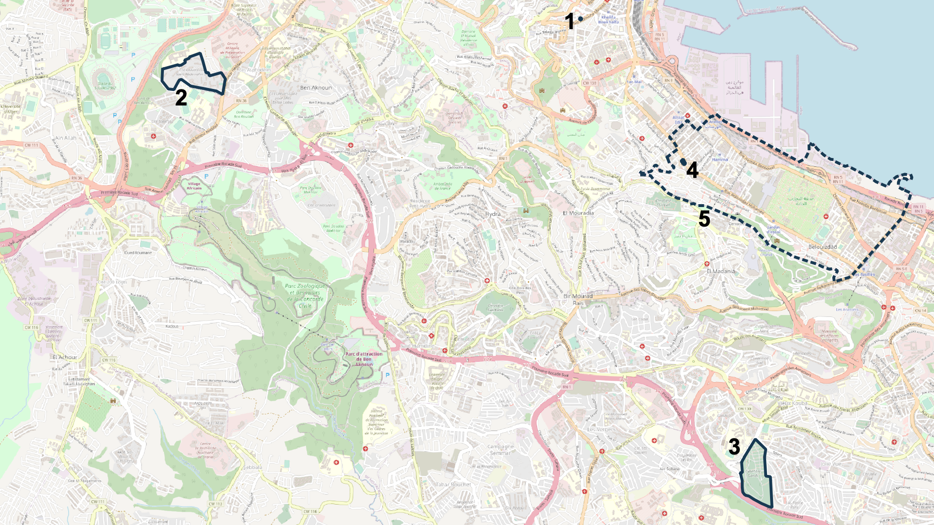
Map 5: Ali in Part Three
- Bouquiniste de la rue Didouche (L’Étoile d’Or)
- Cité universitaire de Ben Aknoun
- Cimetière de Kouba (Cimetière Garidi)
- Monoprix de Belcourt/Banque Extérieure d’Algérie (today)
- Belouizdad/Belcourt
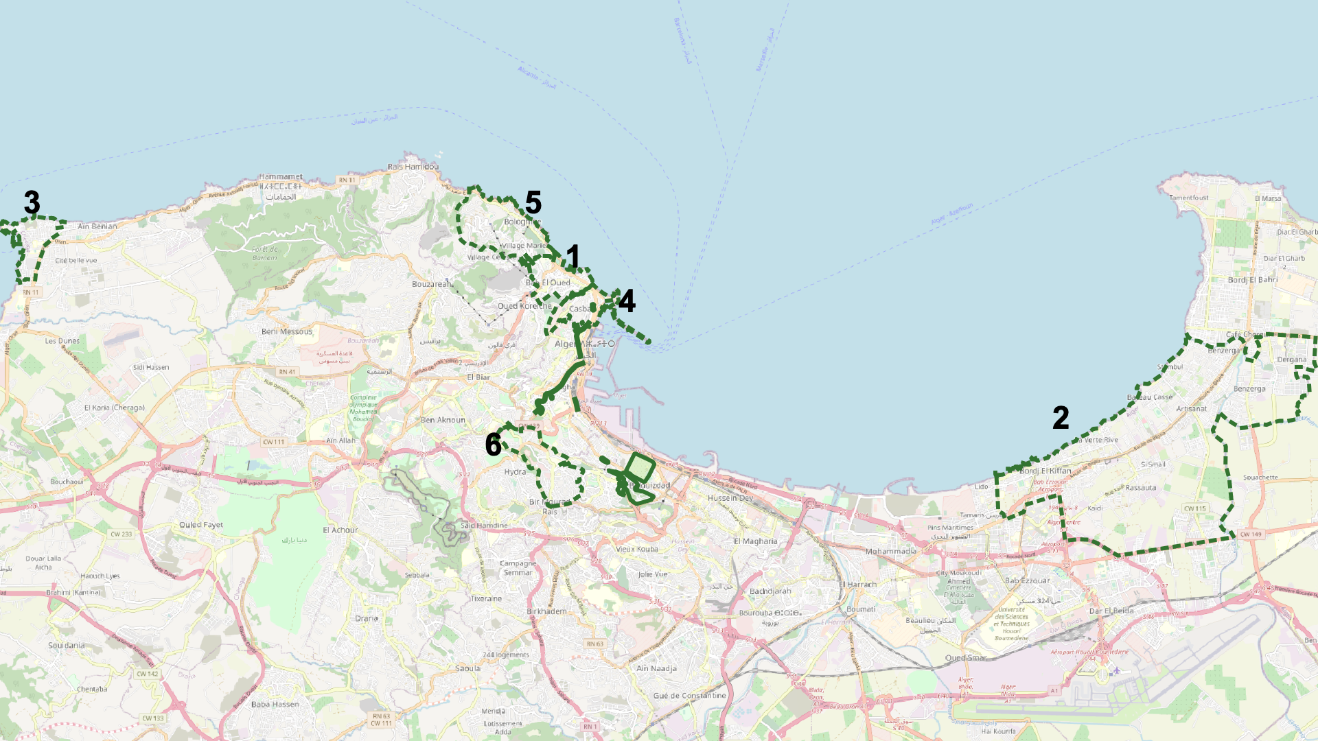
Map 6: Lilas in Part Three (Neighborhoods)
- Bab El Oued
- Fort de l’Eau/Bordj El Kiffan
- La Madrague/El Djamila
- La Casbah
- Bologhine/St. Eugène
- El Mouradia
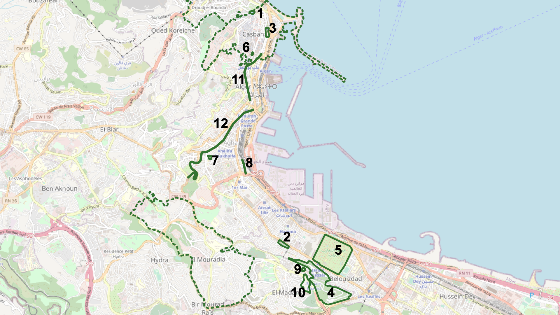
Map 7: Lilas in Part Three (Buildings and Streets)
- Mausolée Sidi Abderrahmane
- Cimetière Sidi M’hamed
- Place du Cheval/Placet El Aoud/Place des Martyrs
- Bois des Arcades
- Jardin d’Essai
- Marché de la Lyre
- Marché Meissonnier
- Rue des Libérés/Rue des Colons
- Mémorial du Moudjahid/du Martyr
- Riadh el Feth
- Rue d’Isly/Rue Ben M’hidi
- Rue Michelet/Rue Didouche
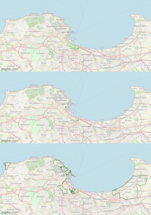
Map 8: Lilas Over Time
What to make of this reversal? The evolution of Lilas’s maps (shown in Map 8) shows compression followed by expansion. Juxtaposed with the previous map, it becomes possible to view Lilas’s extensive urban explorations in the first chapter of Part Three as a reaction to and resistance against the way she was pushed out of public space after her marriage. Beyond her Algiers walks, Lilas’s chapters in Part Three again include many places that I could not map here, but this time for a different reason: they were beyond the scope of this map. Not only does she mention “Le domaine Bouchaoui” and “El Asnam” (229, 230), two places in Algeria but outside Algiers, she also narrates her trip with Ali to Paris:
À chaque pas, j’ai l’impression de tourner les pages d’un livre que j’aurais déjà lu, de retrouver les mots et les images dont je me suis nourrie depuis si longtemps. Le pont Mirabeau, la Seine, le boulevard Saint-Michel, le café de Flore, les jardins du Luxembourg, les Halles, tous ces lieux me replongent dans mes lectures, dans des séquences de films dont je reconnais les décors. Et c’est guidée par Verlaine, Hugo, Zola, Balzac, Baudelaire, Simone de Beauvoir, Modiano et bien d’autres que je déambule dans la ville. (250)
Not only is Lilas exploring and claiming public space, she is doing it in Paris in addition to Algiers, and simultaneously reading the city as a text, just as she did in Algiers (which I will discuss further in the next section).
In contrast, Ali’s map in this section shows a slight shrinkage compared to his map in Part Two while still remaining comparatively consistent. Over the course of the three sections of the novel, his spatial references are thus much less variable than those of Lilas.
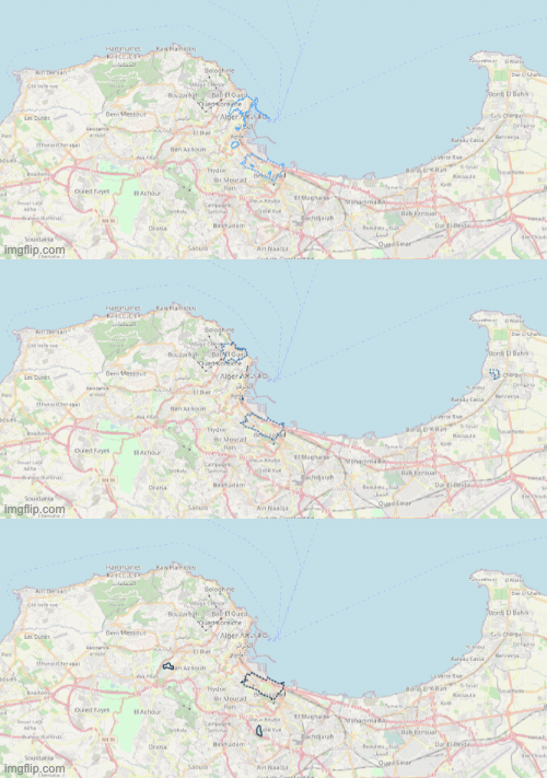
Map 9: Ali Over Time
It is also during this section that Ali begins referencing more places that cannot be mapped, such as his father’s house with his new wife (described as “Quelque part sur les hauteurs d’Alger. Quartier résidentiel” (198)) and the mosque and cemetery where they go for his funeral (202). While it is true, then, that over the course of the novel Ali is generally more overtly concerned with politics and Lilas with more “domestic” matters, their spatial trajectories actually reveal Lilas to have the more expansive and varied experience of the public spaces of the city. Though gender mediates and at times prevents her experience of the city, it is Lilas’s rebellion against that mediation that brings her coming-of-age story full circle and enables her to connect more deeply to the city than Ali does at any point in the novel.
Map as Text, Text as Map
It is perhaps fitting, then, that Lilas herself offers an interpretation of the city as a text during her explorations of it; a closer look at her map reveals the ways in which it is like a text. While taking her walks in Algiers, Lilas reflects, “Toute l’histoire d’Alger est écrite dans ses rues” (189). In a previous version of this project, I discussed the multilayered nature of writing about Algiers, noting that for Lilas, the act of walking through the city brings up not only urban history of what places used to look like or used to be named, but also literary history of how places used to be described (Grabowski 3). The mapping of places mentioned in the novel makes some of these hidden layers rise to the surface. First of all, the process of mapping itself occasionally required some uncovering of layers. For example, Ali references “le Monoprix de Belcourt” twice in the novel, first when his mother is waiting in line for groceries, and again when it is burned during unrest in the city (Bey 133, 256). Mapping this location required unearthing the building that it has since become, a bank (“Le Monoprix de Belcourt se tenait là”). Similarly, the Galeries algériennes are now the Musée public national d’art modern et contemporain d’Alger (“Histoire du bâtiment”), and while the bookseller himself is no longer there, the bookstore of the famed “bouquiniste de la rue Didouche” from whom Lilas buys her books is still on the same street (A., “Hommage à Ami Mouloud”).
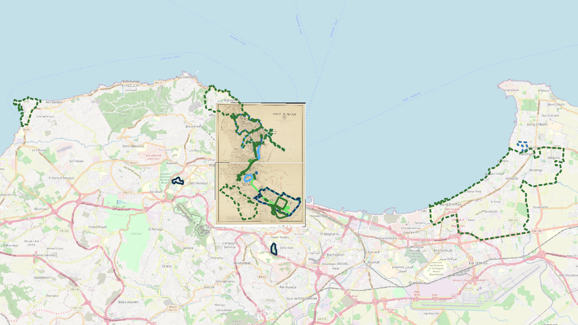
Map 10: Ali, Lilas, and Colonial Algiers (and Beyond)
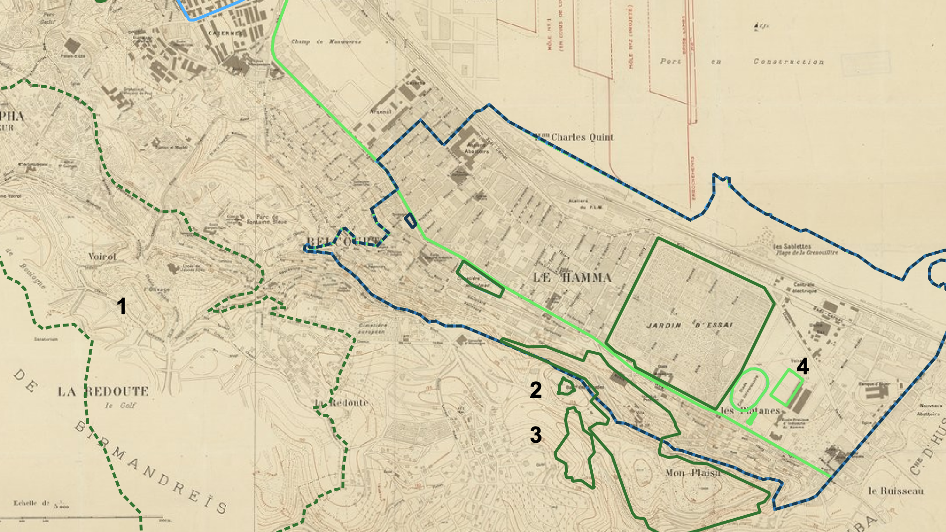
Map 11: Belouizdad/Belcourt
- El Mouradia
- Monument du Moudjahid/du Martyr
- Riadh el Feth
- Lycée Fodhil El Ouartilani
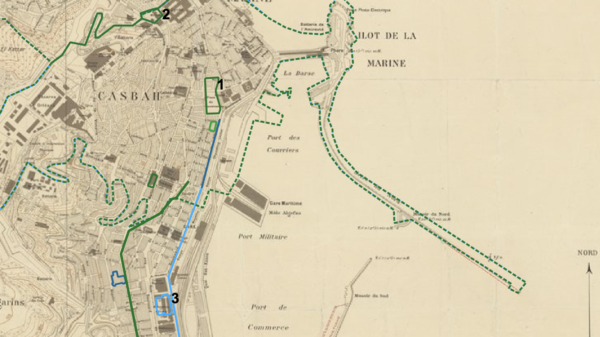
Map 12: La Casbah
- Place du Cheval/Placet El Aoud/Place des Martyrs
- Mausolée Sidi Abderrahmane
- Assemblé Populaire Nationale
The historical layers are sometimes commented upon by the characters themselves, as Lilas does in Part One, but are also sometimes only noticeable by a comparison of the present-day map of Algiers with a colonial one produced by the French. For example, in Map 11, El Mouradia, the neighborhood to which Ali and Lilas move at the end of the novel, is not yet developed enough to have been considered worth mapping; its edges, showing topography rather than urban development, bleed out into blank paper. This map also highlights three locations mentioned by Ali or Lilas that did not yet exist in 1930, when this map was made: the high school where Ali and Lilas study, the Monument du Martyr, and Riadh el Feth. The absence where the novel gives a sense of abundance is striking. Map 12, on the other hand, shows the section mapping the Casbah and surrounding areas, and what is striking here is not absence but difference. What is today the Place des Martyrs, and before that the Place du Cheval, is on the 1930 map the “Place du Gouvernement.” The Mausolée Sidi Abderrahmane is simply described as “Mosquée” and “Ecole arabe.” And the Assemblée Populaire Nationale is superimposed over a former military warehouse (“Manutention militaire”). The comparison of the novel’s maps to the colonial-era map thus reveals that even when not explicitly commented upon by the characters, many places—perhaps all of them, even—are made up of more than what meets the eye.
But in Part Three, the layers Lilas observes are literary as much as they are historical. According to Grabar, the Casbah has been a particular site of French colonial and orientalist fantasy: “The French saw the Casbah as primitive, mysterious and exotic; to them, it was a place that represented Muslim Algerian society as a whole” (Grabar 392). As we saw, the earliest mention of the Casbah in the novel, by Ali, associates it still with sex (Bey 51). In Lilas’s explorations of the city, she firmly rejects this fantasy: “Je ne veux pas écouter les voix de ceux qui racontent les soirées parfumées de jasmin et les nuits parcourues d’airs andalous et de frôlements subreptices. Ceux qui évoquent à mi-voix les femmes enfermées dans les patios ombragés et celles qui s’aventurent craintivement dans les rues, rasant les murs, revêtues d’un voile qui les fait ressembler à des fantômes” (186). But she also crafts a new layer of her own, adding on top of the palimpsest’s layers:
Je préfère me perdre dans les labyrinthes de la Casbah, bastion historique, reconnu et célébré de la tradition. Après avoir fait un détour par la place du Cheval, ou Placet El Aoud, sans y voir de cheval, la statue du duc d’Orléans pointant son épée sur la Casbah ayant été déboulonnée, j’entre enfin dans la vieille ville, autrefois mystérieuse et envoûtante, accrochée au flanc de la colline, préservant jalousement l’intimité et l’inviolabilité de ses maisons aux murs aveugles, séparées par un dédale de ruelles aussi étroites que malodorantes, lieu propice aux délires enthousiastes et à l’assouvissement des fantasmes de multiples voyageurs en mal d’exotisme. La Casbah à présent si délabrée que même ses amoureux les plus fervents s’en détournent et ne rêvent plus que de blocs de béton. (187)
In this passage, the many historical and literary layers of the Casbah are visible all at once. Lilas enters “la place du Cheval,” which had been renamed twenty years earlier, in 1962, as the place des Martyrs (Grabar 399). Regardless, Lilas evokes all historical periods in her narration, and she both sees the violence of the French statue and insists upon its absence. She sees similar layers for the Casbah as a whole, describing how it was (and how it was described) “autrefois” and what it is like “à présent,” as well as insisting on the change it has undergone symbolically, no longer a sought-after place for “ses amoureux.” The novel thus inscribes itself, in a metaliterary moment, on top of—but not obscuring—the layers of the past, becoming, it, too, another layer of the text or map of Algiers.
Lilas’s ultimate identification of Algiers as a woman in this chapter suggests that she herself identifies with the city represented by the map of places she has mentioned, suggesting a possible reading of gender in this novel as a palimpsest. She claims her walks as a way to understand her city’s history: “Mes promenades ressemblent à une espèce de reconstitution historique. Et je ne me lasse pas de déambuler dans cette ville que j’aime tant, Alger, maintes fois conquis, maintes fois libérée. Alger, parfois impudique, jamais vraiment soumise, et qui garde en elle l’empreinte de ces multiples déchirements, reste encore aujourd’hui indocile, indomptable” (Bey 190). The constant use of feminine adjectives and the feminine pronoun “elle,” grammatical though it may be, insists on a potential comparison between Algiers and Lilas, the woman who narrates it. At times mappable and at times not, Lilas’s spatial experience as a woman in Algiers is nonetheless full of layers, one on top of the other, each mention of a place recalling previous mentions of it in her life and insisting upon her right to mention it and claim that public space for herself. It is Lilas who tells the reader where she and Ali will be moving to, after much anticipation: “Nous venons de trouver une maison. Dans un autre quartier. À El Mouradia, précisément. Une maison coloniale, entourée d’un jardin planté d’arbres. Dans une de ces petites rues pentues et tortueuses bordées de petites villas sans prétention qui font le charme de la ville” (266). With Ali and Lilas’s successful move out of the apartment building coming as it does in the novel’s storyline as an ultimate victory, the reader is left with an impression that Lilas has now achieved a comfort level with the city and with public space that she did not always have.
Conclusion: Postcolonial Surface Reading?
Mapping the locations mentioned in Bleu blanc vert, while seemingly an example of surface reading—the process, after all, consisted of scanning the entire text for place names, seemingly antithetical to the notion of close reading—ultimately proved the impossibility of such a reading of this novel and city in particular. Best and Marcus define one of the many types of surface reading as “critical description,” in which “depth is not to be found outside the text or beneath its surface (as its context, horizon, unconscious, or history); rather, depth is continuous with surface and is thus an effect of immanence” (Best and Marcus 11). Mapping this postcolonial novel, however, has shown that in this instance, depth (“context, horizon, unconscious, or history”), rather than being “continuous with surface,” instead is the very surface itself. In Ali’s and Lilas’s Algiers, the surface does not exist and is rather a series of different historical and representational layers that seep through each other. Every place name contains the possibility of a different past or future name, whether or not the different name is explicitly evoked in the text. In the Algerian context, and perhaps more broadly in the postcolonial context, the idea of surface reading becomes inherently political, simultaneously evoking colonial history and its aftermath in the present and the future.
Works Cited
A., Yakine. “Hommage à Ami Mouloud, l’éternel bouquiniste de la rue Didouche Mourad.” 23 September 2016, Algérie 360, https://www.algerie360.com/hommage-a-ami-mouloud-leternel-bouquiniste-de-la-rue-didouche-mourad/. Accessed 28 April 2021.
Best, Stephen, and Sharon Marcus. “Surface Reading: An Introduction.” Representations, vol. 108, no. 1, pp. 1-21, 2009. JSTOR, https://www.jstor.org/stable/10.1525/rep.2009.108.1.1. Accessed 28 April 2021.
Bey, Maïssa. Bleu blanc vert. Éditions Barzakh, 2006.
Grabar, Henry. “Reclaiming the city: Changing urban meaning in Algiers after 1962.” Cultural Geographies, vol. 21, no. 3, 2014, pp. 389-409. JSTOR, https://www.jstor.org/stable/26168581. Accessed 28 April 2021.
Grabowski, Eleanor. “Lilas’s Algiers: A Digital Mapping Project.” 15 March 2021. Remapping Algeria: Poetics and Politics of Space, Columbia University, unpublished essay.
“Histoire du bâtiment.” Musée public national d’art modern et contemporain d’Alger, https://www.mama-dz.com/musee/histoire. Accessed 28 April 2021.
“Le Monoprix de Belcourt se tenait là.” 24 March 2014. Vivre à Belcourt, https://photos.belcourtois.com/picture.php?/289/tags/4-rue_de_lyon. Accessed 28 April 2021.
Moretti, Franco. “Maps.” Graphs, Maps, Trees: Abstract Models for a Literary History. E-book, Verso, 2007. ACLS Humanities E-Book, https://hdl.handle.net/2027/heb.08911. Accessed 28 April 2021.
O’Neill, Dora, Eleanor Grabowski, and Michelle Chen. “Presentation write-up: Bleu blanc vert by Maïssa Bey.” 25 February 2021. Remapping Algeria: Poetics and Politics of Space, Columbia University, unpublished essay.
Data Sources
Map of Algiers, Algeria. Google Maps, 2021, maps.google.com. Accessed 28 March 2021.
Map of Algiers, Algeria. OpenStreetMap, 2021, www.openstreetmap.org. Accessed 28 March 2021.
MapTiler Team. “EPSG:30493.” EPSG.io: Coordinate Systems Worldwide, http://epsg.io/30493. Accessed 15 March 2021.
Société des plans régulateurs de villes (Paris). “Ville d’Alger / dressé par la Société des plans régulateurs de villes.” 1930. Gallica, Bibliothèque nationale de France, 2019, https://gallica.bnf.fr/ark:/12148/btv1b53179735w. Accessed 28 March 2021.