The Long-Term Cost of War: Does So-Called “Proportionality” Require a Redefinition?
The Long-Term Cost of War: Does So-Called “Proportionality” Require a Redefinition?
Introduction
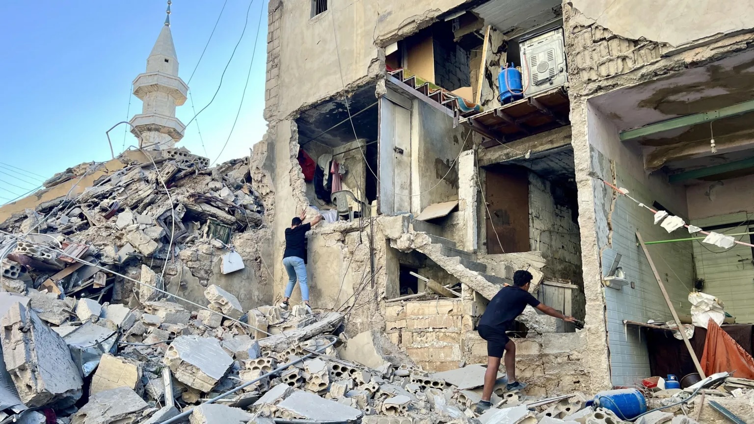
The now simmering conflict between Israel and Hezbollah, which escalated last September 2024, after almost a year of war between Israel and Hamas, has unearthed an uncomfortable reality around the disproportionate and long-lasting impacts of warfare. Civilians, aid workers, and essential infrastructure have either been targeted or caught in the crossfire between the two actors, with the World Bank estimating a loss of US$8.5 billion in Lebanon due to physical damages and economic loss (World Bank, 2024). This project looks at what is missing in the equation of “proportionality”, specifically highlighting the long-term impacts such as 1. Loss of life, 2. Infrastructure damage, and 3. Loss of humanitarian aid and healthcare workers. This project aims to go deeper than recounting the number of attacks or fatalities, but to understand how the attacks may inflict long-term harm on communities.
Escalation in Lebanon
The conflict between Israel and Hezbollah has caused immeasurable damage on both sides of the border. An estimated 1.2 million people in Lebanon and 60,000 in northern Israel have been displaced since October 7th, 2023 (Al Jazeera, 2024), altering the DNA of the cities and towns across the region (Scott, 2012). Over 100,000 infrastructural assets in Lebanon (World Bank, 2024) and thousands of homes in northern Israel were damaged or destroyed (Reuters, 2024), eliminating vital spaces for economic and social interactions (Larkin, 2023).
Utilizing data from the ACLED, Aid Worker Security Database, Humanitarian Data Exchange, WHO, and others, this project looks at the effects of Israel’s bombardment on Lebanon since October 7th, 2023, peaking in September 2024 and ending on December 31st, 2024, after the withdrawal of Israeli troops from Lebanon. Initially, this project endeavored to analyze all the ways in which society is altered by war and how that should be considered when applying the rule of “proportionality”.
However, many media outlets and humanitarian research have already explored the various impacts such as building damange, number of displaced people, and overall mortality rates– so, instead, this project dives deeper into the experience of one city and how the war has altered local citizens’ ability to access basic services, visualizing the extent to which war can paralyze a society. At the same time, it celebrates the simultaneous continuation of life and urban phenomenon amid disaster and violence.
Proportionality and Loss of Life
Per international humanitarian law (IHL), proportional warfare assumes that “incidental loss of civilian life, injury to civilians, damage to civilian objects, or a combination” is not excessive relative to the military advantage won (ICRC, n.d..). However, “IHL provides no objective standard for assessing what constitutes excessive civilian harm in relation to a given military advantage” (Medecins Sans Frontieres, n.d.). If Hezbollah alleges that 500 of its fighters were killed in Israel’s offensive in Lebanon (Reuters, 2024), does this outweigh the death toll among civilians in Lebanon? Does it outweigh the reverberating effects of Lebanon’s real GDP growth, which fell by 6.6% this last year (World Bank, 2024)?
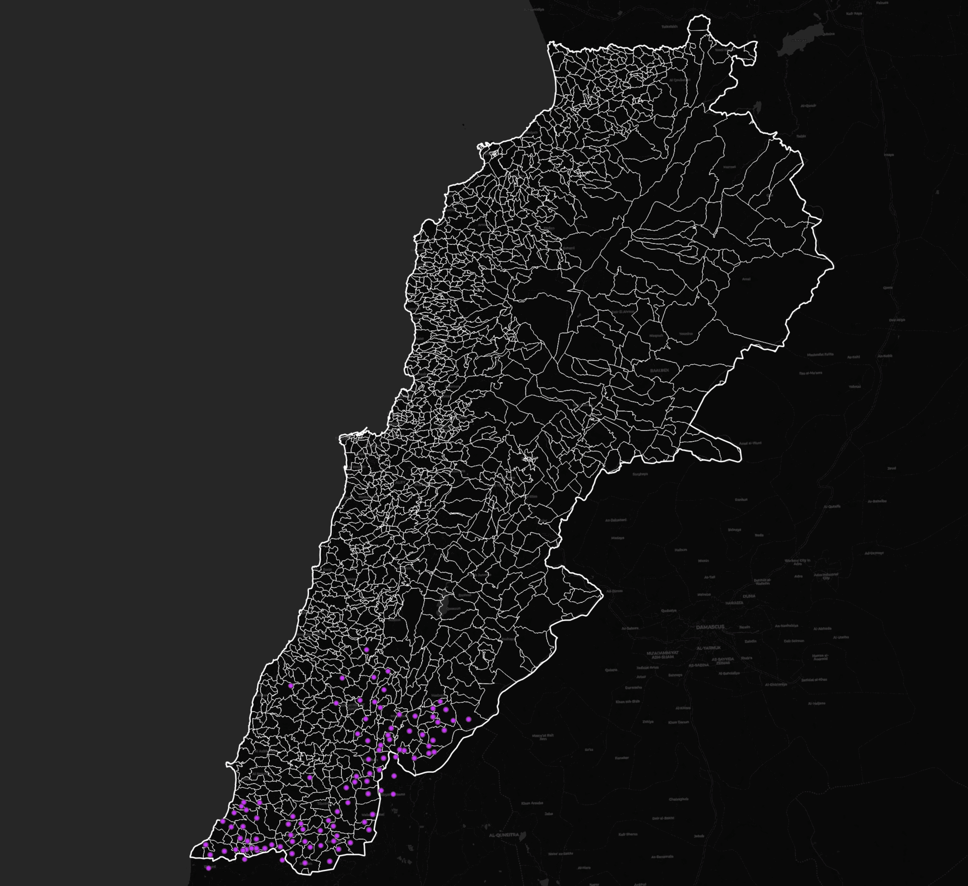
This chloropleth map portrays the density of fatalities in Lebanon between Oct. 7th, 2023, and Dec. 31st, 2024. There were 4,751 total fatalities that occurred in Lebanon by Israeli militants. Of the 4,751 fatalities, 2,922 were civilians– although it’s important to note that the Lebanese Health Mininstry doesn’t distinguish between civilian and combatant but ACLED’s dataset does. The deaths are catagorized as the following…
- 2850 were killed by air/drone strike
- 10 were killed in land attacks
- 5 were killed by remote explosive or landmines
- 57 were killed in shellings
The death of over 4,000 people distinctly changes the fabric of society and armed conflict, in general, reveals cross-sectoral development gaps that lead to lasting impacts (Vesco et al., 2024). With majority of attacks occurring by drone strike, the next step in the analysis was looking at how the strikes affect life beyond the fatalities.
Zooming in on the Every Day Impacts
Source: Armed Conflict Location & Event Data Project (ACLED), 2025.
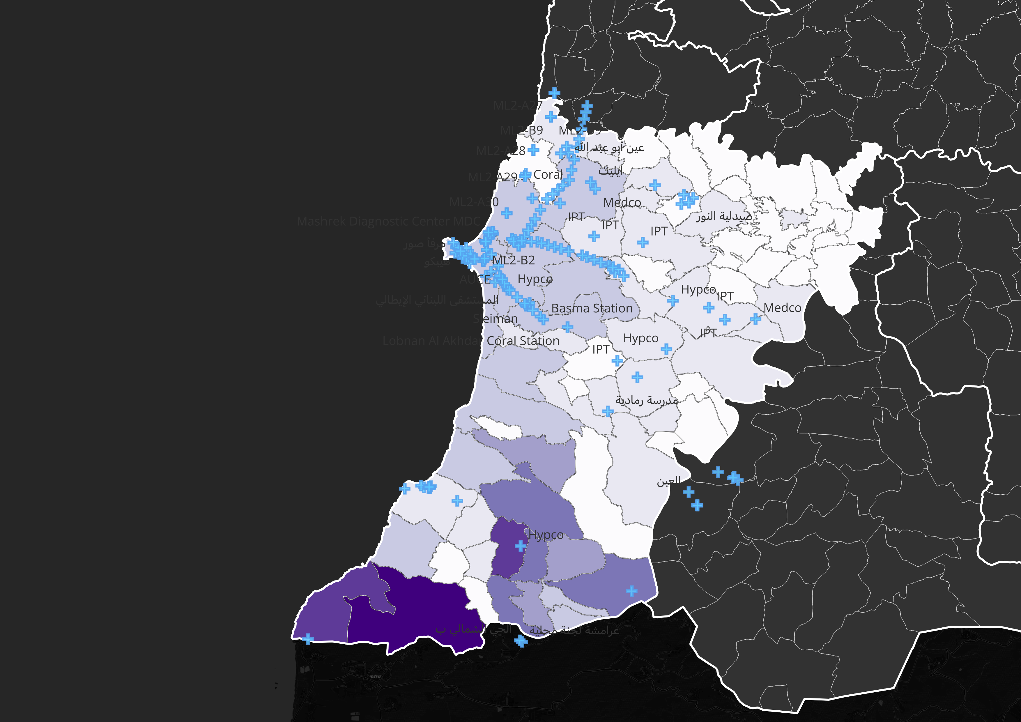
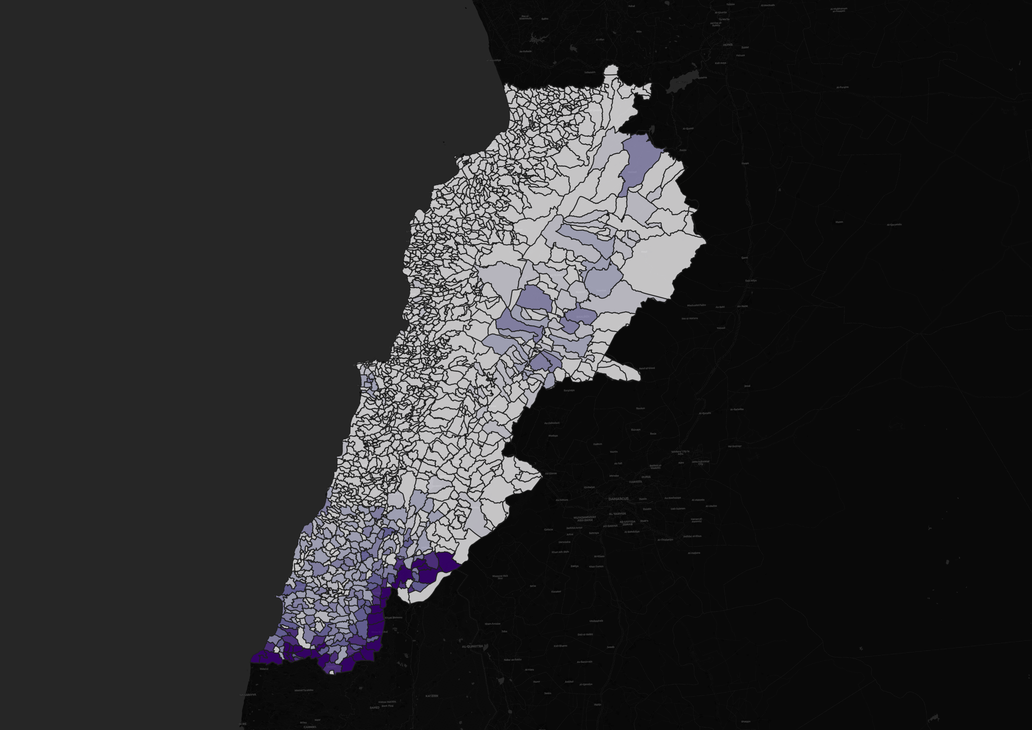
Sources: Admin boundaries (HDX, 2024), Basic services points (HOTOSM, 2024), Total attacks (ACLED, 2025).
Between October 7, 2023, and December 31, 2024, Lebanon experienced a total of 14,812 incidents of violence carried out by Israeli forces. Among the areas most heavily impacted was the governorate of Tyre—also spelled Tyr or Sour in various datasets. Located along Lebanon’s southern coast, Tyre is one of the oldest continuously inhabited cities in the world. Once a thriving Phoenician city, it is home to Roman ruins that still stand today, and it is historically credited as the birthplace of the color purple, derived from sea snail pigments (Ancient Color).
Tyre endured over 4,211 attacks during this period, resulting in 661 recorded fatalities. The governorate was selected as a case study not only because of the scale of destruction it endured, but also because it represents a unique duality: its archaeological and cultural fragility, juxtaposed against its urban resilience in the face of repeated conflict.
The accompanying map visualizes the concentration of Israeli attacks overlaid with the locations of essential public infrastructure—including healthcare facilities, schools, water sources, and energy nodes. This spatial relationship reveals that violence was not evenly distributed, but rather clustered in areas critical to civilian survival and community functioning. The damage to these networks extends the impact of war beyond immediate casualties, disrupting access to services for tens of thousands of residents. It suggests that proportionality in conflict must not only account for the number of lives lost, but also the sustained deprivation of basic human needs that follows in the wake of repeated attacks on vital infrastructure.
Disproportionality, Civilian Impact, and the Weaponization of Essential Services
The principle of proportionality in warfare is often narrowly interpreted as a ratio between military advantage and civilian harm. But what happens when the civilians affected are humanitarian aid workers or doctors, and the infrastructure destroyed includes clinics and hospitals? Does proportionality account for the compounding effects of destroying life-sustaining institutions? When healthcare facilities are bombed and aid convoys targeted, it’s not only immediate casualties that must be counted—but also the lives at risk due to the loss of access to essential services in the days, weeks, and months that follow. And in the absence of functioning institutions, who will communities turn to for survival?
Since October 2023, Lebanon has recorded 137 attacks on healthcare personnel and infrastructure (WHO, 2024) and 16 attacks on humanitarian aid workers (AWSD, 2024). These assaults not only disrupt emergency response during conflict, but also undermine post-conflict recovery and long-term health outcomes. The effects ripple through the system—especially in underserved areas like southern Lebanon, where service coverage was already fragile.
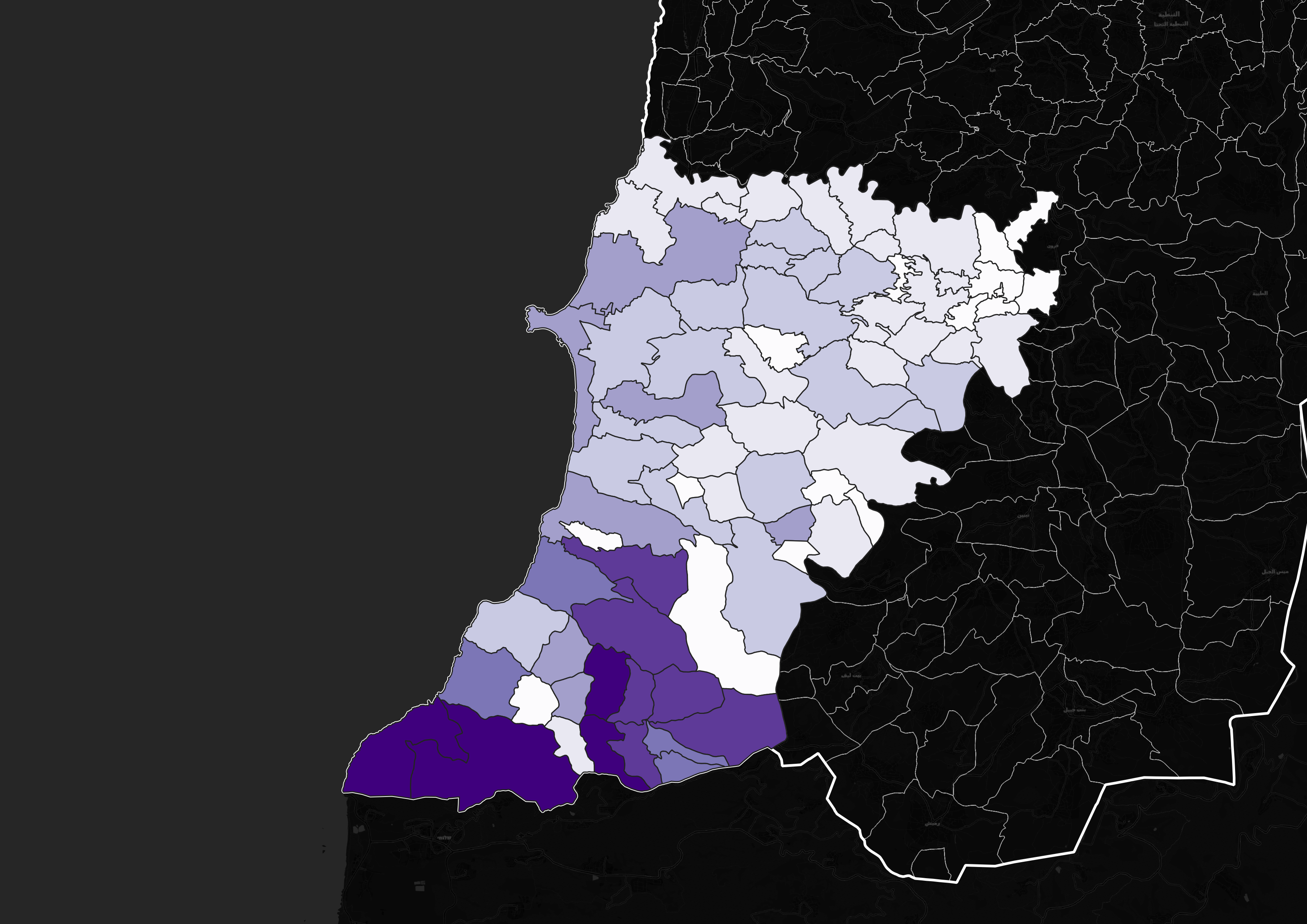
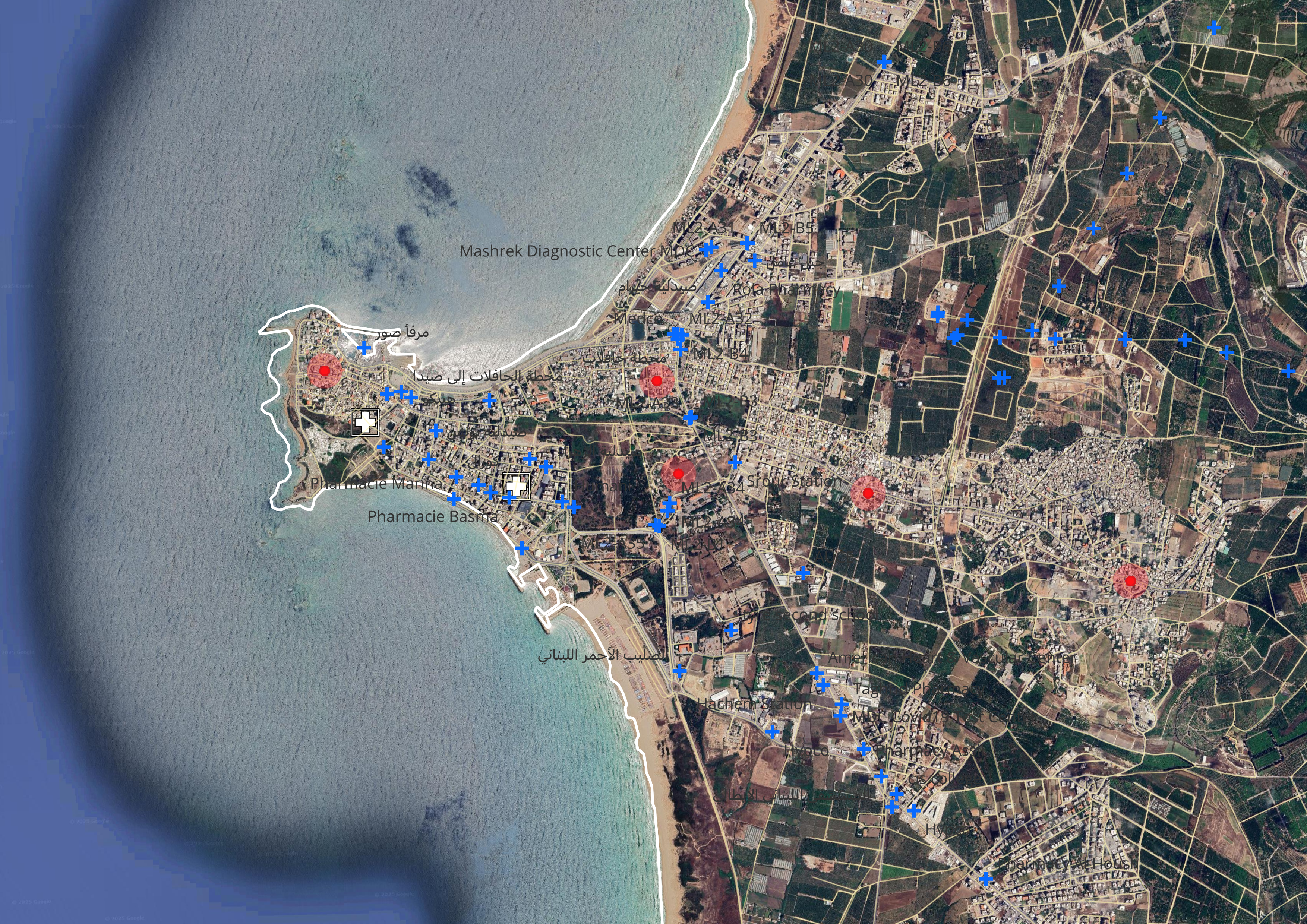
Zooming in a little closer to the city of Tyre, this map identifies Israeli attacks relative to basic services and roads. The red explosion symbols represent confirmed Israeli strikes, while blue crosses denote healthcare facilities and social service points. Although the WHO data does not have public locations for where heathcare workers were attacked, there is data on humanitarian aid worked impacted in Lebanon with corresponding latitude and longitude. Attacks on humanitarian aid workers including reported fatalities are denoted as the white crosses. Major road networks and urban boundaries are overlaid for reference. This map makes visible the dense clustering of attacks around vital civilian infrastructure. Clinics, pharmacies, hospitals, and diagnostic centers are all within proximity of strike zones—posing an existential threat to those already vulnerable.
Infrastructure in Tyre Pre- and Post-Conflict
Source: Youtube, Amazing Places on Our Planet Al Jazeera
Source: Youtube, Al Jazeera Al Jazeera
Researchers agree that the destruction of urban spaces during conflict has increased over the first quarter of the 21st century (Wroth, 2025). Battle fields have shifted to dense urban areas where paramilitaries and insurgents have embedded themselves into the local population. As a result, more citizens are implicated during episodes of violence and the destruction of buildings and infrastructure lead to higher levels of fatalities and displaced people.
The two videos highlight the cultural richness of Tyre while achknowledging its fragility and impermanence amid conflict. The aerial bombardment on Tyre threatens the lives of citizens, humanitarians, and healthcare workers, but it also redefines a place’s identity and history on a level that is not only seen but felt.
Building Damage
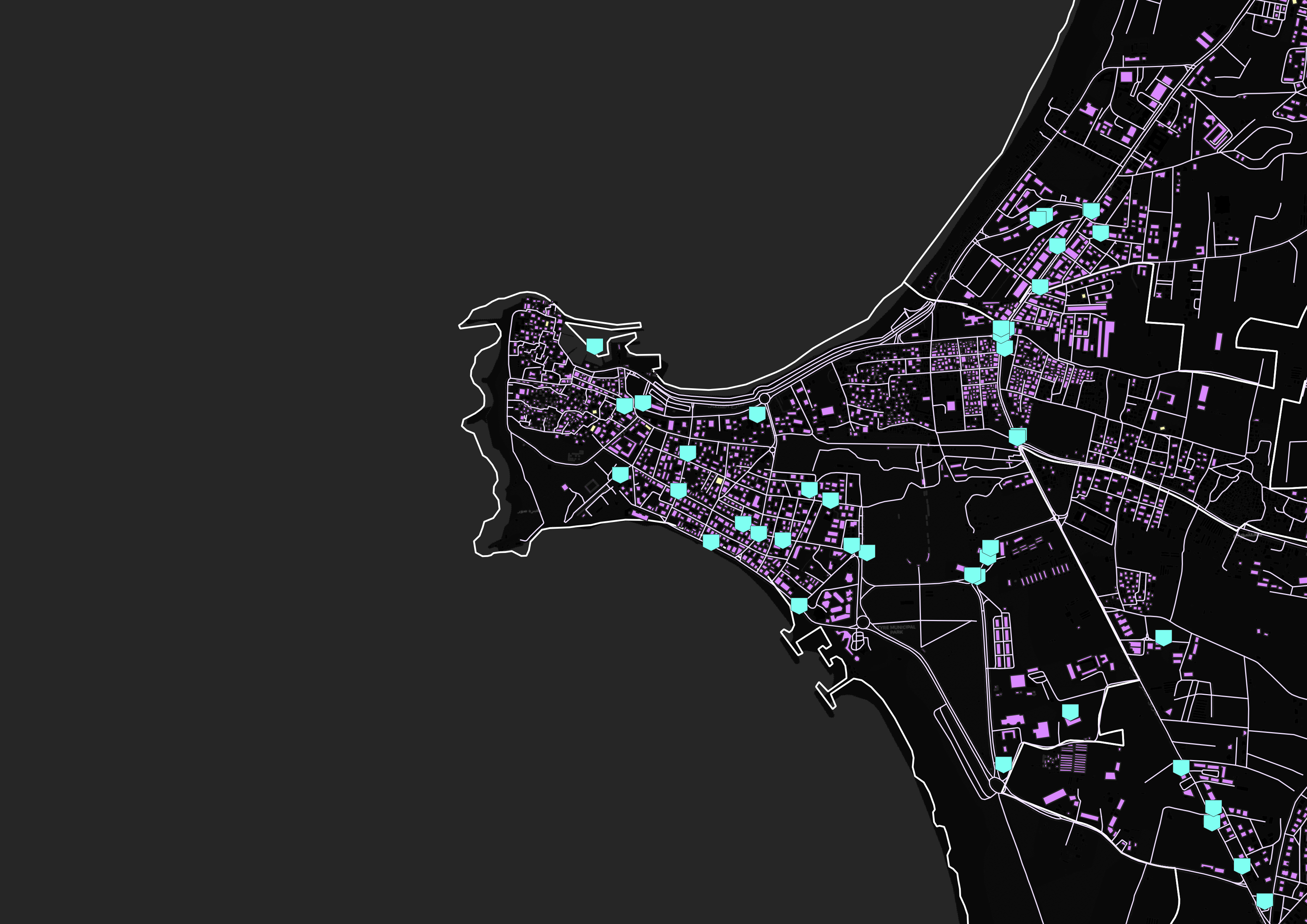
Source: OpenStreetMap & Geofabrik satellite mapping, 2023.

Sources: OpenStreetMap & Geofabrik satellite mapping, 2025.
While war often brings destruction and displacement, cities can also demonstrate a remarkable degree of resilience and continuity even amid ongoing violence. Urban centers, by their nature, are not only targets but also adaptive ecosystems—places where reconstruction and growth can occur simultaneously with conflict. In Tyre, a city marked by its ancient heritage and contemporary strategic significance, this tension is particularly visible.
To assess the tangible physical impact of the conflict, this study conducted a comparative analysis of building development and damage in Tyre before and after the escalation of violence between October 2023 and December 2024. Surprisingly, the imagery analysis revealed limited visible destruction in the zones where airstrikes were recorded. While this may partially reflect the limitations of satellite imaging or OpenStreetMap’s post-strike detection capacity, it also prompted a deeper observation: urban development in Tyre actually expanded during this period.
As illustrated in the comparative images above, new structures—represented by emerging purple blocks—appear most noticeably in the northeastern quadrant of the city. This suggests that despite the escalation of hostilities, residential construction and urban growth continued, possibly fueled by population movement, returnees, reconstruction efforts, or private investment. In conflict-affected areas, such growth can signal not only recovery but also shifts in displacement patterns, informal rebuilding, or changes in land use driven by humanitarian or political interests.
This observation reinforces a key insight: urban areas are not static victims of war, but dynamic spaces that evolve in response to it—sometimes in unexpected ways. The case of Tyre challenges the notion that conflict necessarily halts development and invites us to consider how urban systems adapt, resist, and rebuild under pressure.
Conclusion
This project demonstrates that the impacts of war cannot solely be measured by death tolls or the number of drone strikes alone. The principle of “proportionality,” as interpreted and widely agreed upon in international humanitarian law, fails to capture the full arc of destruction when applied narrowly—especially in urban environments where the reverberations of violence extend far beyond the blast radius. In cities like Tyre, the consequences of conflict ripple through the physical landscape and into the daily rhythms of civilian life, disrupting access to essential services, displacing families, and eroding the social fabric of entire communities.
The impact on essential infrastructure such as medical facilities, schools, and water filtration systems has a long term impact on a society. In the case of Lebanon, this impact is exacerbated as the Lebanese government has, so far, failed to respond to the needs of citizens most impacted in the South governorate. A Reuter’s report in November 2024 stated that Hezbollah was handing out cash to people affected by the hostilities, including displaced people. What does this mean for sustainable peace?
But amid the devastation, cities also reveal their resilience. Tyre stands not only as a site of loss, but also as a symbol of adaptation. Despite over 4,000 attacks and hundreds of civilian deaths, the city witnessed continued construction, suggesting that urban life persists even under the shadow of war. This tension between destruction and development, fragility and strength, is what makes urban centers both uniquely vulnerable and deeply vital in times of conflict.
Ultimately, this project calls for a redefinition of how we evaluate the cost of war. If the goal is to uphold human dignity and safeguard the conditions for recovery, we must broaden our understanding of proportionality to include not just lives lost, but futures constrained. The long-term cost of war is written not only in casualty reports, but in the destroyed health facilities, evacuated schools, and fractured urban landscapes left behind.
References
Administrative & Geographic Data
ACLED. (2025). Armed Conflict Location & Event Data Project. https://acleddata.com/
GeoFabrik. (2024). Lebanon – OpenStreetMap Downloads. https://download.geofabrik.de/asia/lebanon.html
Humanitarian Data Exchange. (2024). Lebanon administrative boundaries dataset. https://data.humdata.org/dataset/cod-ab-lbn
HotOSM. (2024). Humanitarian OpenStreetMap export for Lebanon service points. https://export.hotosm.org/v3/exports/f3641dc5-d640-49f8-9b85-3df8b1d10c32
Health & Humanitarian Aid
Aid Worker Security Database. (n.d.). Security incidents involving aid workers (2023–2024). https://www.aidworkersecurity.org/
World Health Organization. (2024, November 22). Lebanon: A conflict particularly destructive to health care. https://www.who.int/news/item/22-11-2024-lebanon–a-conflict-particularly-destructive-to-health-care
World Health Organization. (2024). SSA Healthcare Attacks in Lebanon (2023–2024). https://extranet.who.int/ssa/LeftMenu/PublicReportList.aspx?start=2023-10-07&end=2024-12-31&countryList=122&typeList=1,2,4,3,5,7,6,9,10
Conflict, Media & Reporting
Al Jazeera. (2024, November 5). Death toll from Israeli attacks on Lebanon surpasses 3,000 – Health ministry. https://www.aljazeera.com/news/2024/11/5/death-toll-from-israeli-attacks-on-lebanon-surpasses-3000-health-ministry
Al Jazeera. (2024, November 17). Mapping Israeli attacks on Lebanon’s healthcare system. https://www.aljazeera.com/news/2024/11/17/mapping-israeli-attacks-on-lebanons-healthcare-system
Al Jazeera. (2025, January 28). How many people has Israel killed in Lebanon since the ceasefire? https://www.aljazeera.com/news/2025/1/28/how-many-people-has-israel-killed-in-lebanon-since-the-ceasefire
AP News. (2024, September 28). Israel-Palestinians-Lebanon-United Nations. https://apnews.com/article/israel-palestinians-lebanon-united-nations-12e02fd82f35a8438aa907ca6762bac0
Reuters. (2024, November 26). Costs of Israel-Hezbollah conflict mount for both Lebanon and Israel. https://www.reuters.com/world/middle-east/costs-israel-hezbollah-conflict-lebanon-israel-2024-11-26/
Reuters. (2024, November 27). Hezbollah faces long recovery as officials fear thousands of fighters lost to Israel. https://www.reuters.com/world/middle-east/hezbollah-faces-long-recovery-officials-fear-thousands-fighters-lost-israel-2024-11-27/
Political & Development Analysis
Human Rights Watch. (2025, February 17). Lebanon: Destruction of infrastructure preventing returns. https://www.hrw.org/news/2025/02/17/lebanon-destruction-infrastructure-preventing-returns
International Crisis Group. (2016, March 14). Exploiting disorder: Al-Qaeda and the Islamic State. https://www.crisisgroup.org/global/exploiting-disorder-al-qaeda-and-islamic-state
United Nations Development Programme (UNDP) Lebanon. (2025, January). From crisis to recovery: Local authorities confronting post-war realities in Lebanon – Rapid impact assessment.
World Bank. (2024, November 14). New World Bank report assesses impact of conflict on Lebanon’s economy and key sectors. https://www.worldbank.org/en/news/press-release/2024/11/14/new-world-bank-report-assesses-impact-of-conflict-on-lebanon-s-economy-and-key-sectors
Theory & Context
Larkin, B. (2013). The politics and poetics of infrastructure. Annual Review of Anthropology, 42(1), 327–343.
Répertoire du droit humanitaire. (n.d.). Proportionality. Guide to the Humanitarian Law. https://guide-humanitarian-law.org/content/article/3/proportionality/
University of Michigan – Kelsey Museum of Archaeology. (n.d.). Ancient Color: Purple. https://exhibitions.kelsey.lsa.umich.edu/ancient-color/purple.php
Scott, J. C. (n.d.). InfraPolitics and Mobilizations: An Afterward.
Vesco, P., Baliki, G., Brück, T., Döring, S., Eriksson, A., Fjelde, H., Guha-Sapir, D., Hall, J., Knutsen, C. H., Leis, M. R., Mueller, H., Rauh, C., Rudolfsen, I., Swain, A., Timlick, A., Vassiliou, P. T., Von Schreeb, J., Von Uexkull, N., & Hegre, H. (2024). The impacts of armed conflict on human development: A review of the literature. World Development, 187, 106806. https://doi.org/10.1016/j.worlddev.2024.106806
Wroth, K. (2025, January 29). As wars rage, cities face a dark new era of urban destruction - Lincoln Institute of Land Policy. Lincoln Institute of Land Policy. https://www.lincolninst.edu/publications/land-lines-magazine/articles/as-wars-rage-cities-face-dark-new-era-of-destruction/
Multimedia & Visualization
YouTube. (2024a, November). Israeli bombing in Southern Lebanon [Video]. https://www.youtube.com/watch?v=v9U_LuHXf9Y
YouTube. (2024b, December). Ancient Ruins of Tyre Lebanon. [Video]. https://www.youtube.com/watch?v=U7OO9GmUcdU