Urbanization of The Rural
The case of Chiloe and Bengaluru
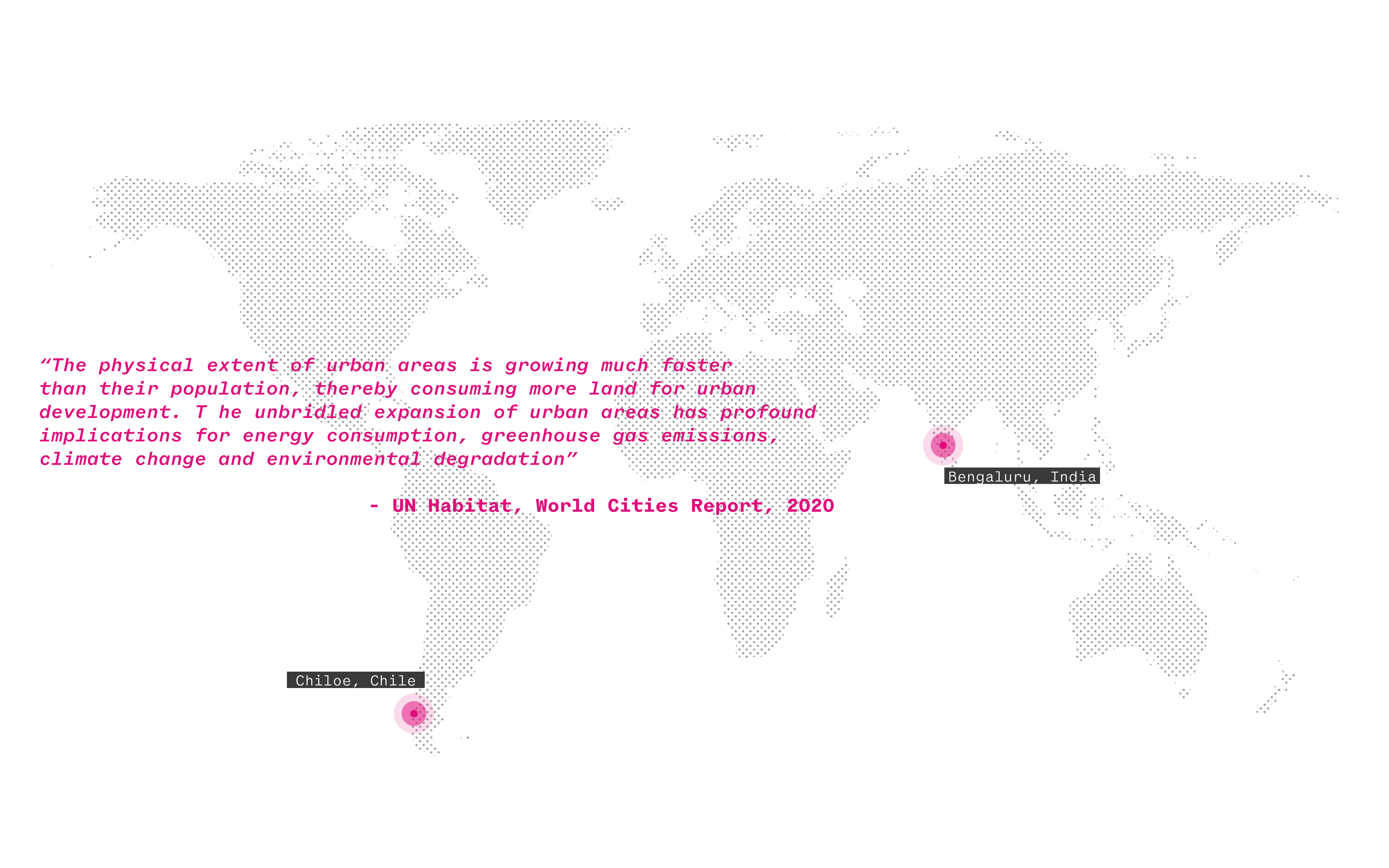
The following research strives to understand the past, present, and future urbanization patterns of rural areas in the island of Chiloe and the City of Bengaluru located in the south of Chile and the south of India, respectively. The study's objective will be focused on understanding the structures that promote urbanization and the conflicts established by the urban-rural dichotomy. By visualizing and analyzing the patterns and policies of urbanization in Chiloe, Chile and Bangalore, India - we illustrate the factors causing urbanization and speculate on the impacts of urban growth on the rural and its ecosystem.

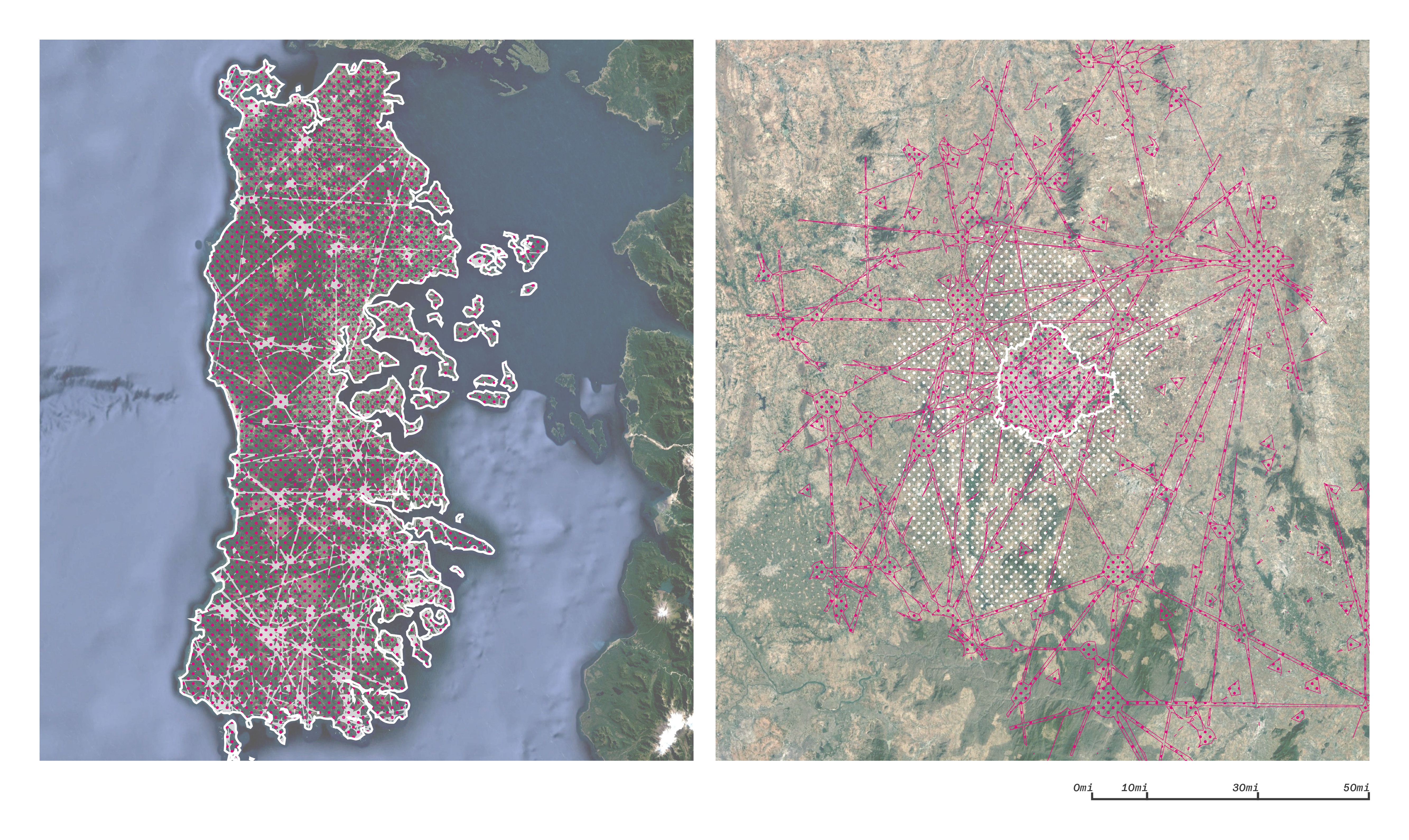
Landsat image of Chiloe, Chile (Left) and Bengaluru, India (Right) / Map Data: Google, Image Landsat / Copernicus
Chiloe, Chile
Context
The province of Chiloé is formed by the Chiloé Archipelago, located in the south of Chile with an area of 9181 km2 . It is one of the main tourist attractions in the country, well known for its churches, traditions, and unique landscapes. The province has a population of 168,185 inhabitants, who are concentrated in the three most populous cities: Ancud, Castro and Quellón.
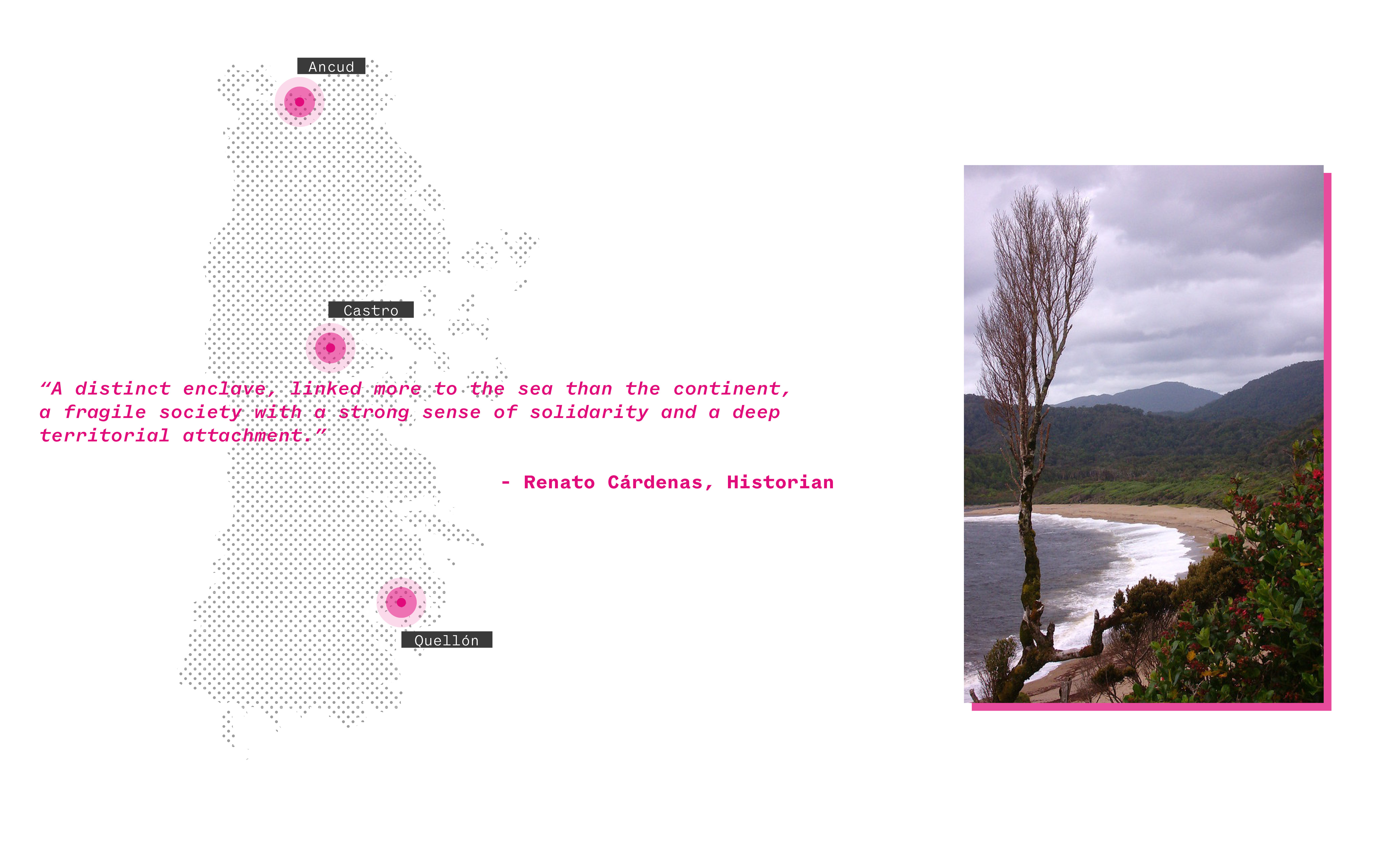
Photo Source: "Chiloe" by Feffef is marked with CC BY-NC-SA 2.0
Chiloe is a mix of rolling green hills and blue waters on the eastern side and a rocky coastline pounded by the mighty Pacific Ocean to the west. This island has pristine landscapes, including winding rivers, lakes, and lagoons with a fascinating array of flora and fauna. The unique landscape shapes the culture of local communities known as Chilotes. The island is the second-largest in South America, cut off from the mainland by the Chacao Canal
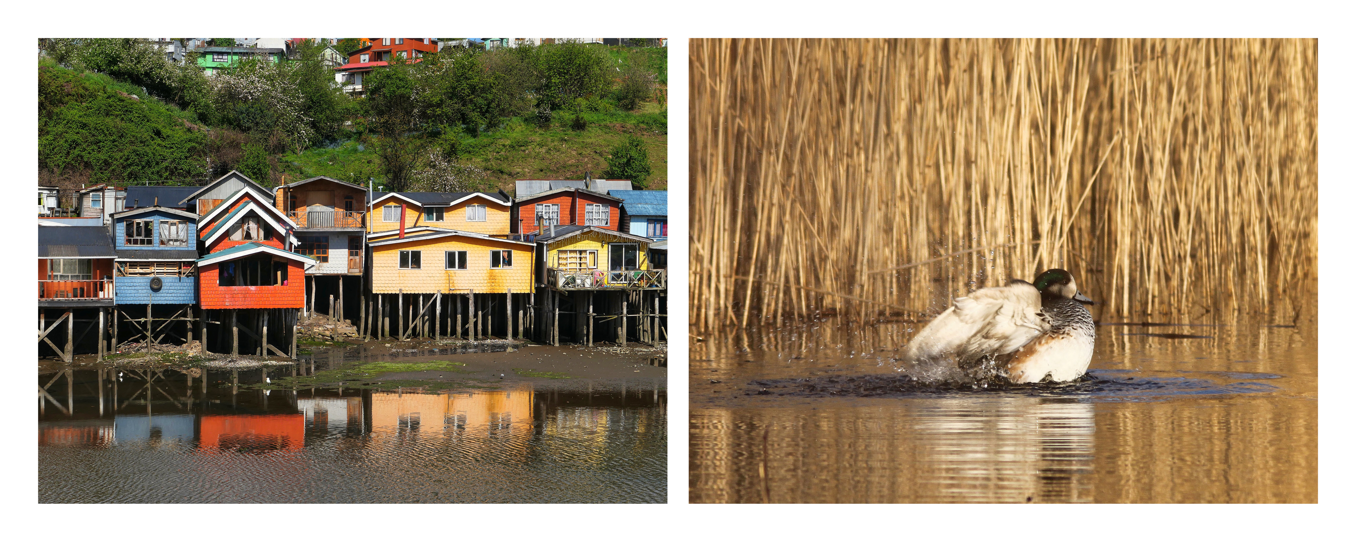
Rural settlement (Left) and Ecology (Right) in Chiloe, Chile / Photo Source: "Palafitos of Chiloe" by VinceTraveller is marked with CC BY 2.0 and "Chiloe Wigeon" by LJWDevon is marked with CC BY-NC-SA 2.0
Connectivity // Puente Chacao
After years of public debate, the fixed connection between "Isla Grande de Chiloé" and the Chilean mainland will be established. The Chacao Bridge is estimated to be ready by 2025, and it will be a hanging structure with a length of 2,750 meters, which will link the continent with the island over the Chacao Channel. The bridge will reduce the journey to just 3 minutes and create better accessibility for its inhabitants and visitors.
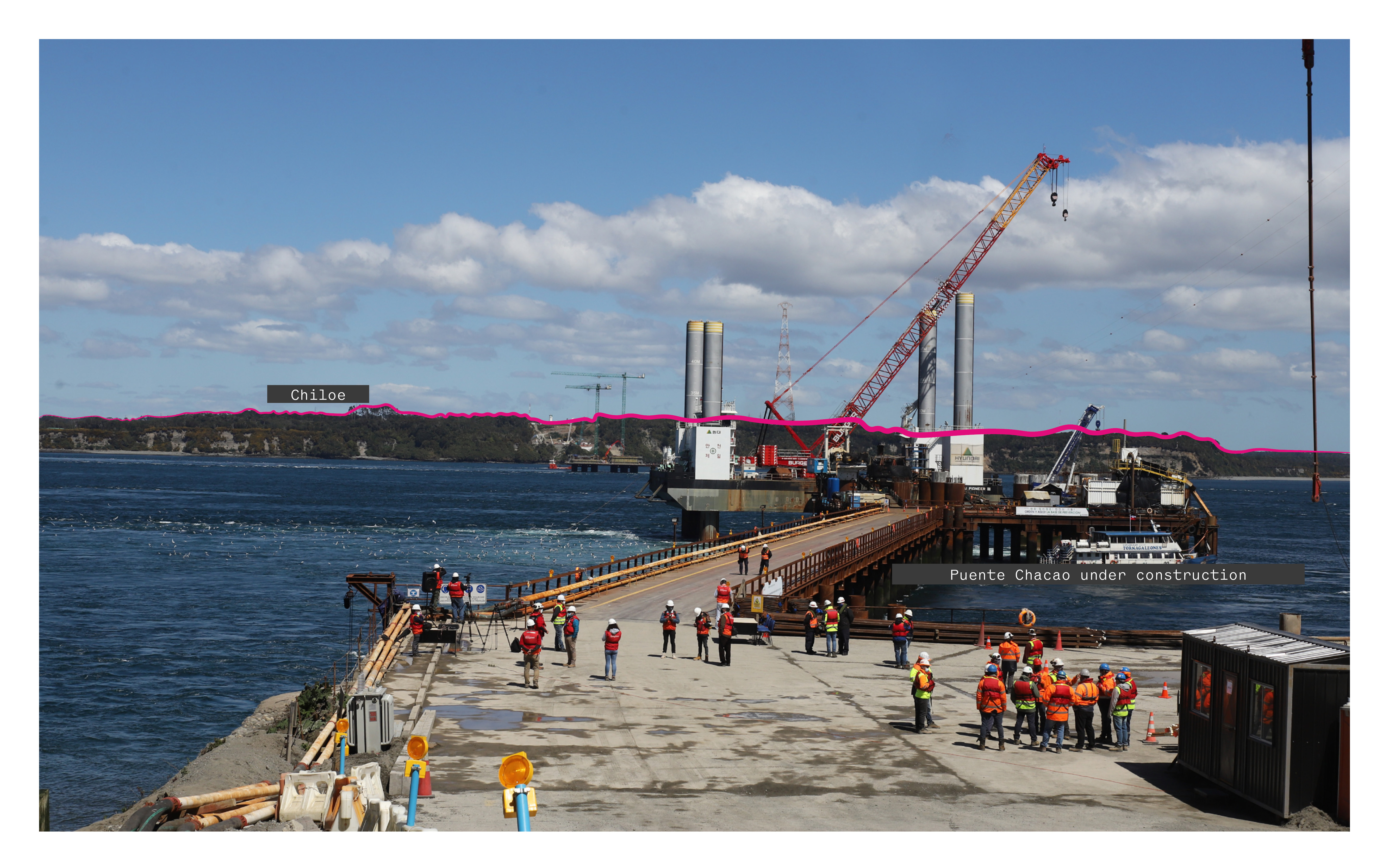
Puente Chacao under construction, connecting the mainland to Chiloe / Photo Source: "El Ministro de Obras Publicas Alfredo Moreno, realizo una visita inspectiva a la construcción del Puente de Chacao" by Ministerio de Obras Públicas is marked with CC BY-NC-SA 2.0 / Diagrammed from original
There has been a controversial discussion about the bridge and its future. It can be argued that without sustainable planning and adequate legislation, the island will be negatively affected by the proliferation of development projects that do not consider the island's natural landscape and cultural traditions.
Connectivity // Policy // Decree 3516
As part of its early stage urbanization process Chiloe is facing a rapid proliferation of land subdivisions with clear residential purposes in rural areas near the coast, lakes, national parks, and riverbanks. The origin of this problem lies in Decree Law No. 3,516 of 1980, which established the rules on the subdivision of agricultural, livestock or forestry rural land to no less than 5,000 m {+2} in the so-called "pleasant plots", and that prohibited changing their agricultural use to the lots resulting from the subdivision.
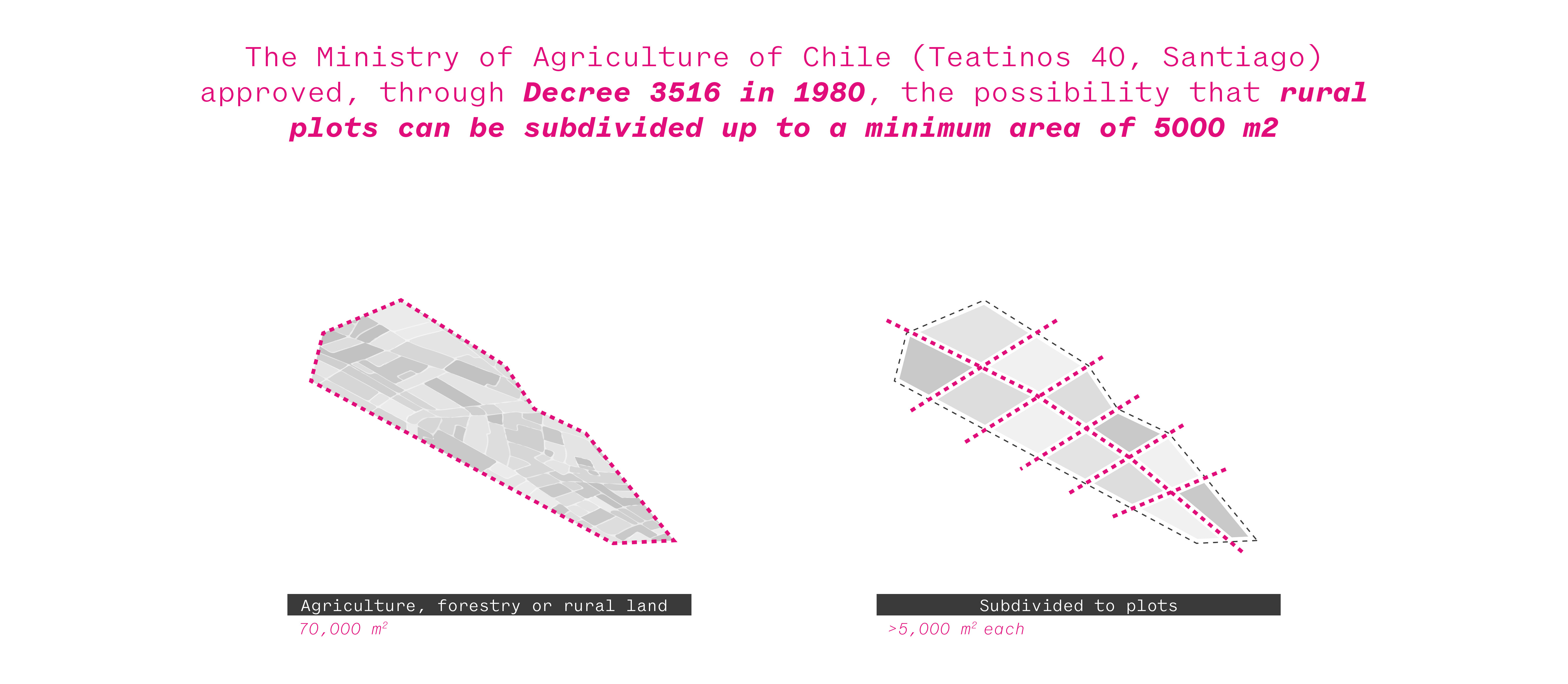
Spatial illustration of decree 3516
“These communes have an agricultural vocation, so by subdividing fields you are reducing the arable or livestock area. You end up eliminating the local, traditional culture and you generate pressure in the territory, inflation in nearby land, because there is an excess demand for acquiring land in Patagonia” (diario financiero, 2022)
In 2021 alone, a significant number of applications were received to create new land subdivision projects in Chiloe. A relevant share of these subdivision projects is to sell plots of 5,000 m2, the minimum subdivision area for agricultural land allowed by law in rural areas. Near the more urban areas of the Island, the buyers are local middle-class people looking to build their first homes. But in the more rural areas near rivers and bays, large pieces of land are being bought by real estate investors from outside the region. Investors have subdivided plots and sold them for a second -or third- home or as an investment to local investors or foreigner buyers that are speculating on the land's future price..
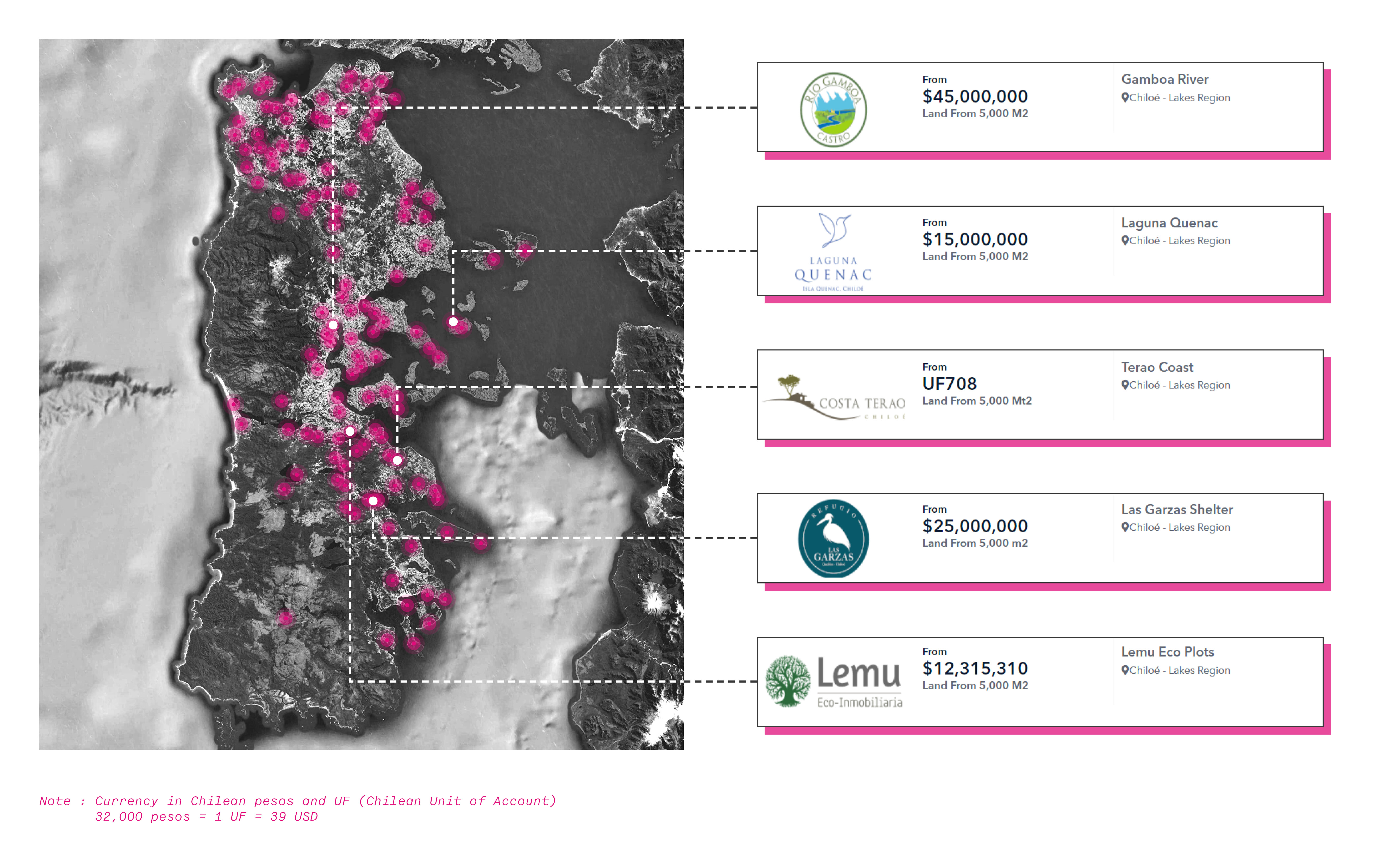
Location map of parcelized agriculture land for sale in Chiloe / Map Data: Google, Image Landsat - Copernicus and; Property data and website clipping: Portal Terreno - Diagrammed from original)
According to people in the area, between 2014 and 2020, the surplus value of land in the region rose ten times. If the hectare used to be sold for between $2 million and $3 million pesos, it could cost now $40 million peso. For the same reason, the local community and farmers-despite the warnings and problems this brings to Chiloe they have- began to sell.
Because of the bad practices in the use of this regulation and the granting of permits for the construction of single-family condominiums in rural areas, today we are facing the loss of land rich in natural and agricultural resources, with an irreversible environmental impact, such as the dismemberment of the ecological mosaic, fragmentation of biodiversity corridors and overload of municipal services, without internalizing the social and environmental costs of hidden suburbanization.
Study Case // Parcelación Río Vilcún
The Parcelacion Río Vilcún Chiloé is located on a 57-hectare Rustic Property that in its first stage lots 45 exclusive parcels whose variety includes: meadows, saplings, river banks and panoramic views, of a minimum of 5,000 m2 surrounded by an environment full of tranquility and nature. The project is being promoted to foreigner buyers from other regions of the country as “the best investment for your future”

Illustration of the parcelization process at Parcelación Río Vilcún / Property data: Parcelacion Río Vilcún Chiloé and Map Data: Google, CNES - Airbus - Diagrammed from original.
By analyzing the project, there is no clear urbanization plan with the possibility of generating new settlements. Many sites do not have access to roads, do not have water, and even less are urbanized with clean sanitation and a clear environmental protection plan. The new housing poles in natural landscapes are located in areas that "are not prepared for this type of densification," says the NGO Center for the Study and Conservation of Natural Heritage (CECPAN) statement.

Aerial view of lots 11-18 in Parcelación Río Vilcún / Photo Source: “Panoramic lot 11-18” by Parcelacion Río Vilcún Chiloé
Speculation // Growth of Land Subdivisions Around Río Vilcún
The generation of these new housing poles in unplanned areas causes territorial segregation and the demand for local governments to provide essential services they can't offer. Hidden suburbanization in Chiloe is creating an irreparable modification of the rural landscape , altering these territories' cultural identity and agricultural vocation.
The island of Chiloe is facing devastating consequences such as "an important loss of native forest, due to land clearing; the destruction of valuable ecosystems, as well as the affectation of species of special value or vulnerability." (diario financiero, 2022)

Speculative illustration of a potential phase 2 at Parcelación Río Vilcún and surrounding developments ecological impact / Property data: Parcelacion Río Vilcún Chiloé and Map Data: Google, CNES - Airbus - Diagrammed from original
Bengaluru, India
Context // Post-independence India
Like many other developing countries, urban sprawl is a growing phenomenon in India, posing socio-economic and environmental challenges that worryingly affect urban sustainability. However, urban sprawl can generally be defined as a rapid and disorderly expansion of built land cover, with low population density and change characterized by the speed of urban area growth outstripping the rate of population growth (Cobbinah et al., 2015; Jaeger et al., 2010).
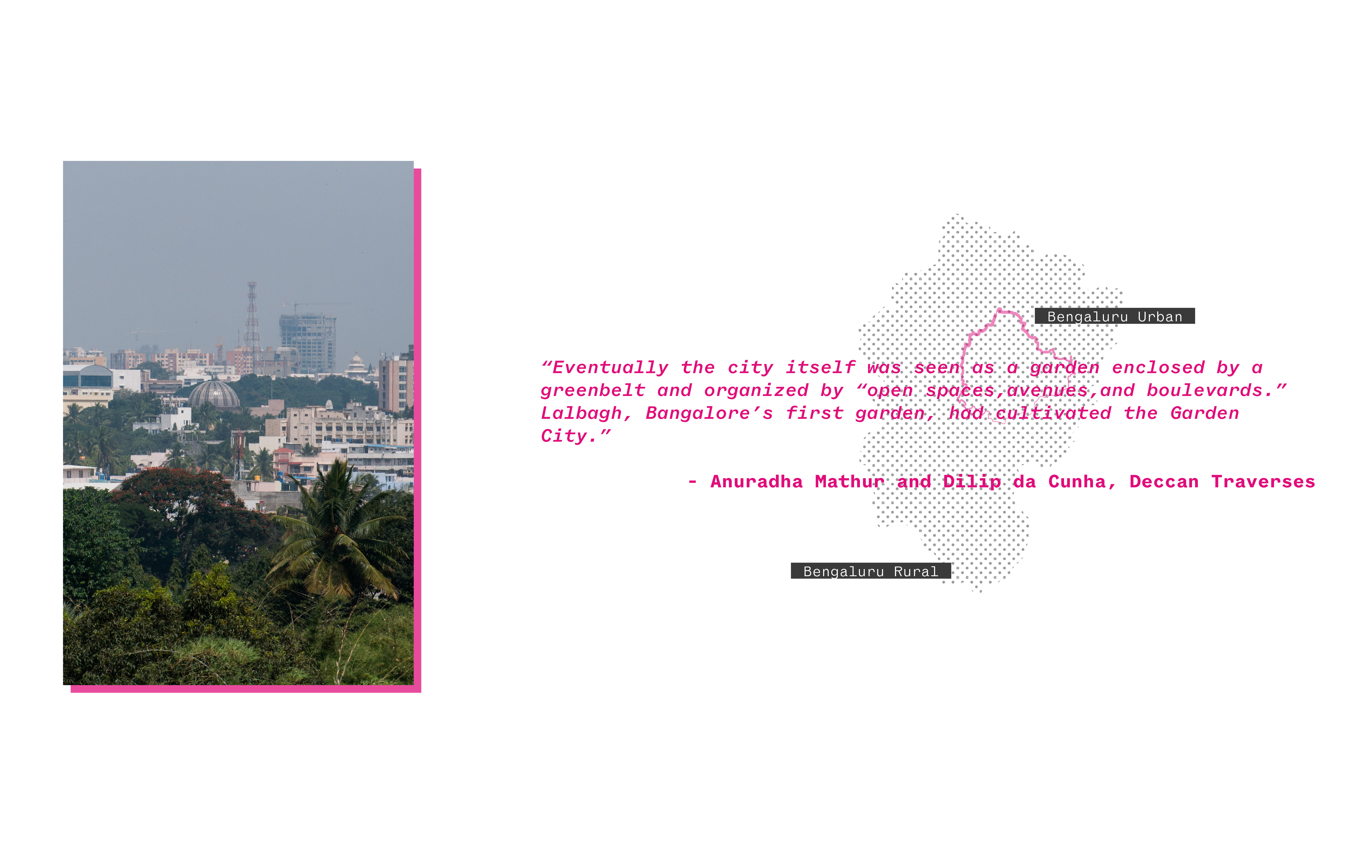
Bengaluru context, India / Photo Source: "Bangalore city view from Lalbagh Botanical Garden" by John Nefastis is marked with CC BY-NC-ND 2.0
After its independence India has focused on development through rapid industrialization, this attitude has shaped the policies and investment patterns. Nehru, the first prime minister of India laid out the plan to modernize India and believed that rapid industrialization was the most effective way to win the battle against mass poverty. These foundational frameworks along with subsequent policies, and disconnected rural economies shaped urbanization in the context of Bengaluru, India.
Industrialization // Bengaluru, Silicon Valley of India
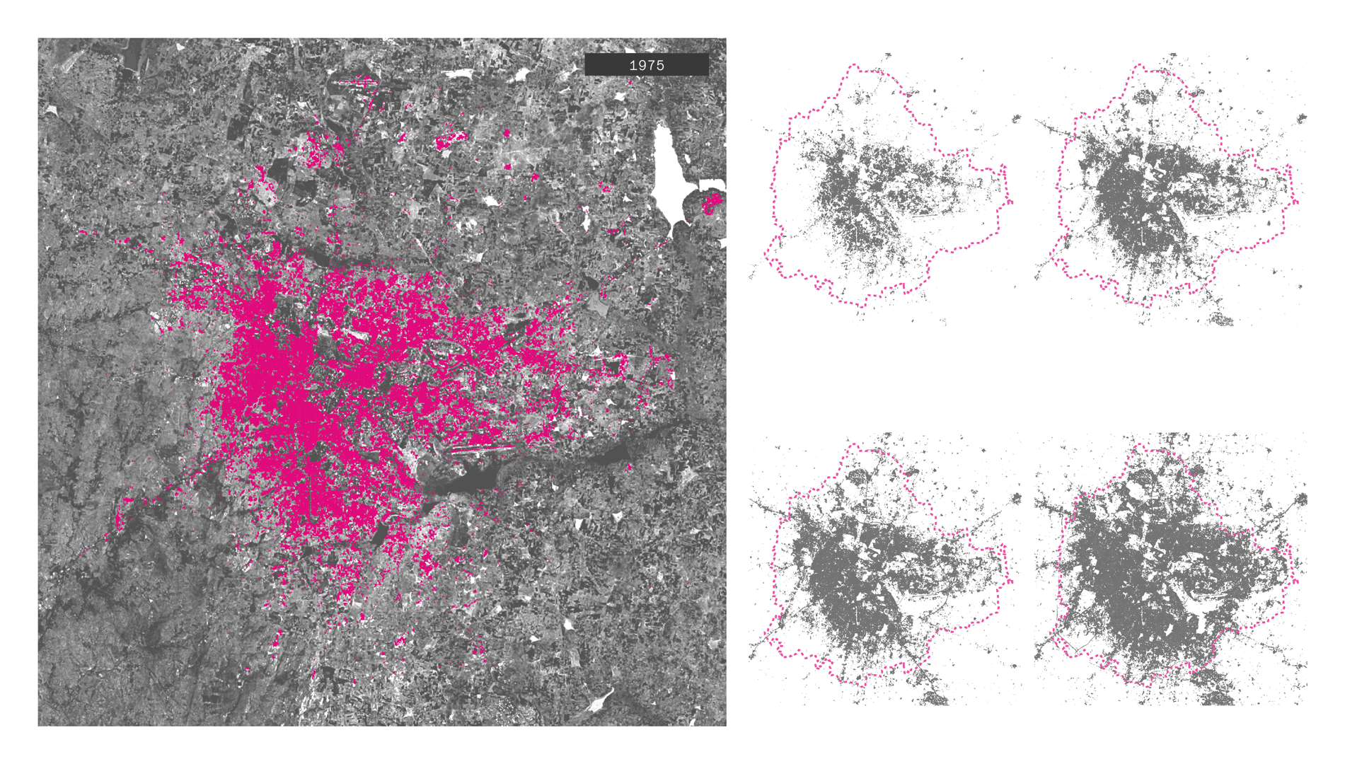
Bengaluru’s urban growth, 1975-2014/ Map Data: Google, CNES / Airbus, Maxar Technologies / Diagrammed from original with Spatial data: “MAPPING INDIA'S URBANISATION”, Kshitij Batra / Diagrammed from original
Bangalore has witnessed rapid urban growth in the last three decades alongside the rise of the tech and software industries and the inflow of foreign capital investment. Economic liberal policies and the rapid densification of the peripheries through the acquisition of cheap rural land, introduced tremendous changes to the national economy, as well as to the city of Bangalore. The effects of the rise of IT and related industries on real estate and commodification of land in the city have been widely studied (Goldman, 2011; Idiculla, 2016). The real estate boom was most visibly articulated in the southern and eastern parts of the city where the IT industry was located (Rao and Suman, 2020). This was accompanied by a growth in informal settlements in the city and by the expansion of the metropolitan area. The economic reforms and rise of the IT sector had crucial implications for the existing industrial economy in the city.

Texas Instruments, one of the first IT companies to setup in Bengaluru/ Photo Source: "Texas Instruments, Bangalore" by seaview99 is marked with CC BY-NC-SA 2.0
Policy // Sub-urban SEZ
The rapid transition has led to unplanned growth and management, especially in terms of infrastructure and services. The area of the city recorded a significant increase of 92.1%, and the population increased by 37.8% from 1991-to 2001. The spatial expansion of the urbanized area has increased from 226 sq km in 1995 to 710 sq km. Such explosive growth cannot sustain without comprehensive land-use planning policies and a city vision for the area's future.
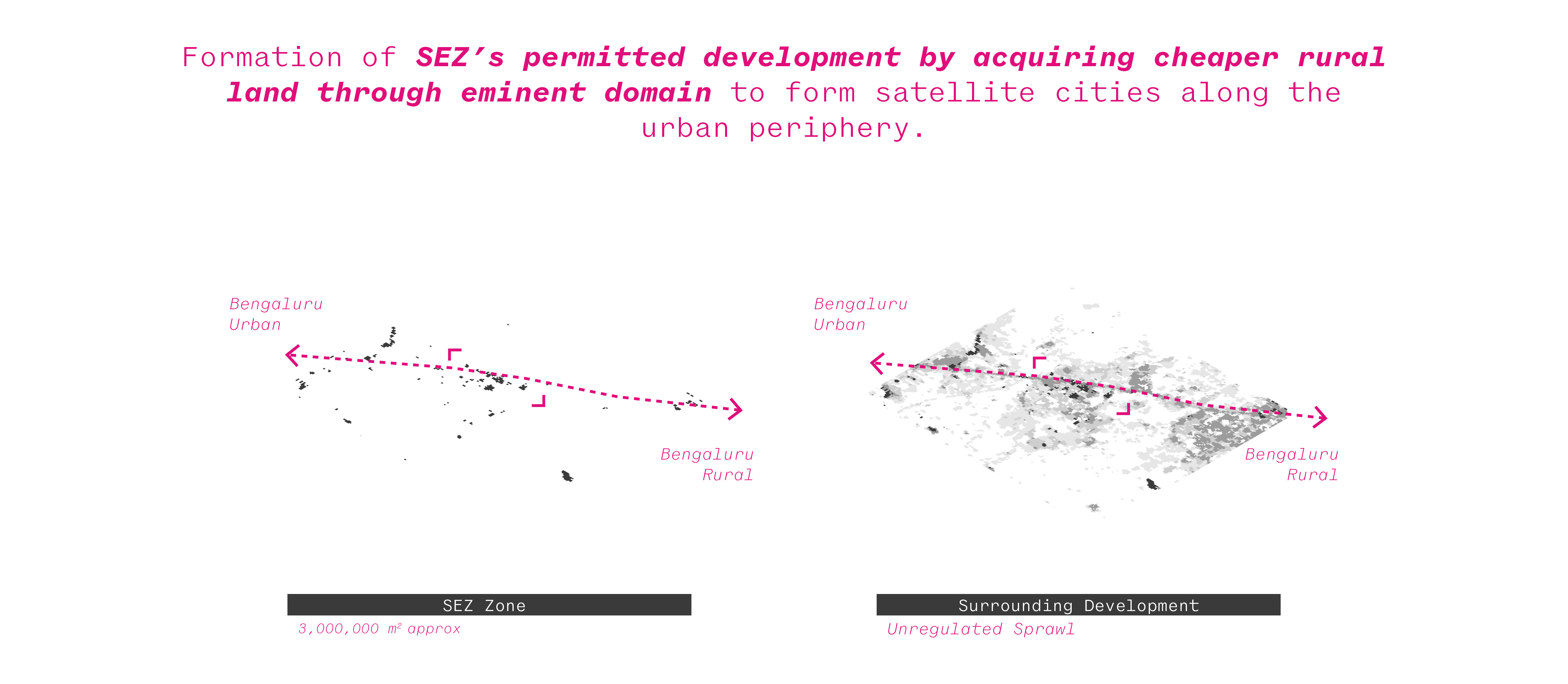
Spatial illustration of SEZ (Special Economic Zone) development
Peripheral areas have gradually become the engine of economic growth with the establishment of IT industries in the peripheral areas of Bengaluru. However, this rapid expansion of the peri-urban interface is a challenge to development. They include a competition of land resources for agricultural and non-agricultural uses as well as a sharp increase in land values. Unrestricted and uncontrolled expansion causes adverse environmental conditions resulting in a substantial cost to the environment. Although many economic impacts were factored into land-use decisions, most environmental externalities were not. The lack of sustainable land use planning policies in expanding the periphery of Bengaluru has caused irreversible problems to its surrounding environment and communities living in the area.
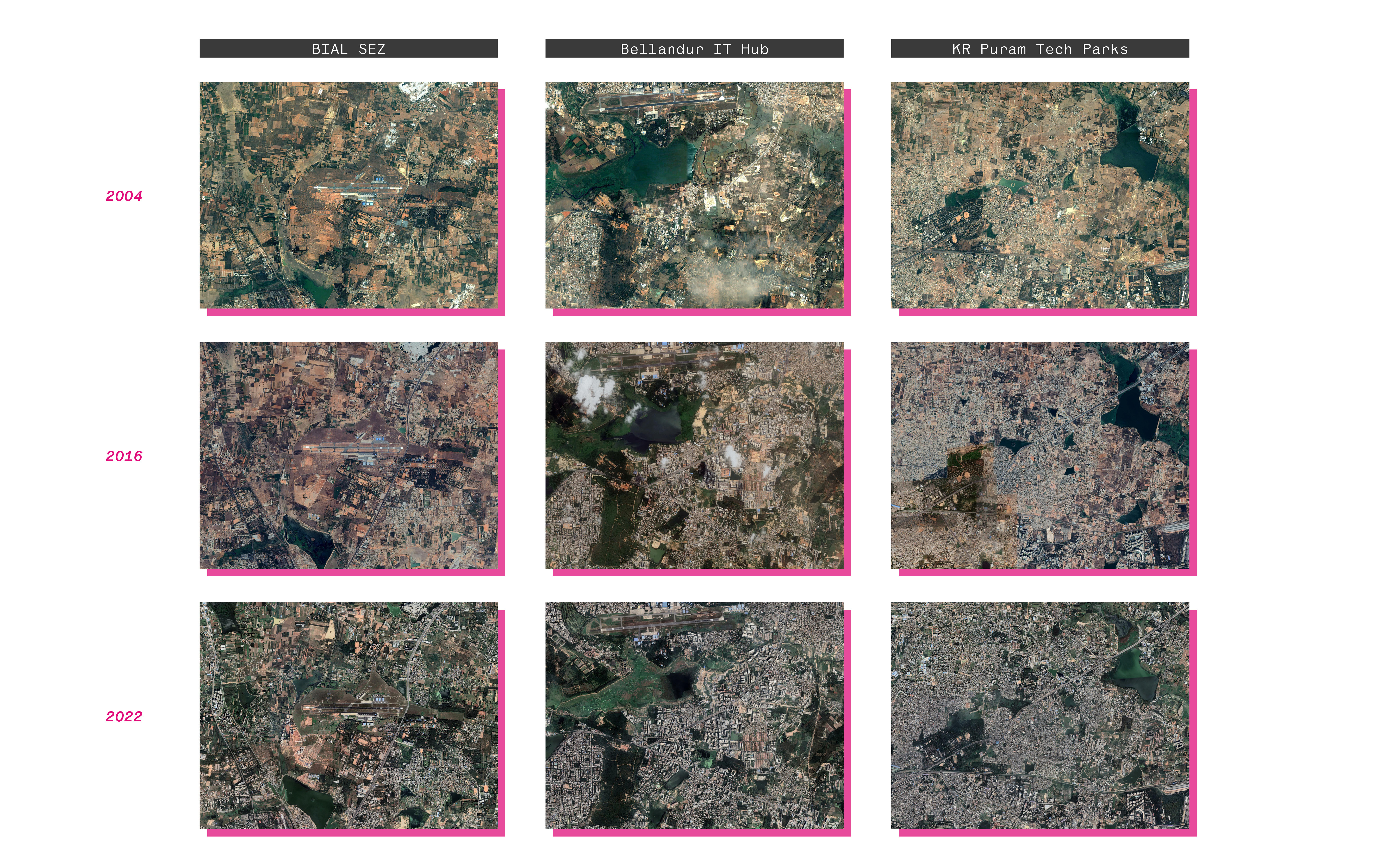
Sprawl illustrated across time by various SEZ’s in Bengaluru / Map Data: Google, CNES - Airbus, Maxar Technologies
Study Case // Electroic City
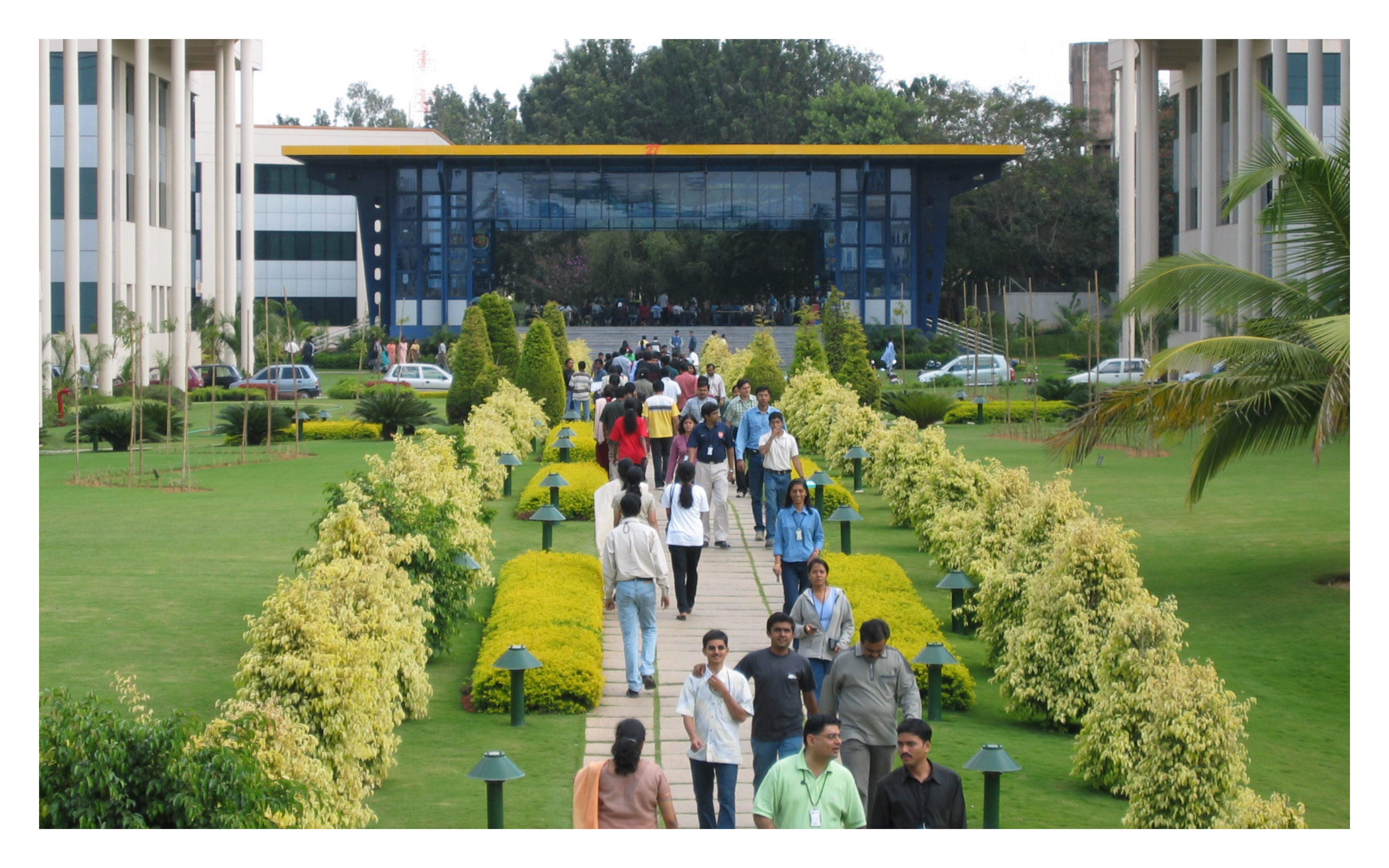
IT Park in the Electronic City SEZ / Photo Source: "File:Infosys.Electronic.City.Lunch.Time.JPG" by Zondor at English Wikipedia is marked with CC BY-SA 3.0

Sprawl illustrated across time by in the Electronic City SEZ / Map Data: Google, CNES / Airbus, Maxar Technologies - Diagrammed from original with Spatial data: “MAPPING INDIA'S URBANISATION”, Kshitij Batra / Diagrammed from original
Implication // Electronic City
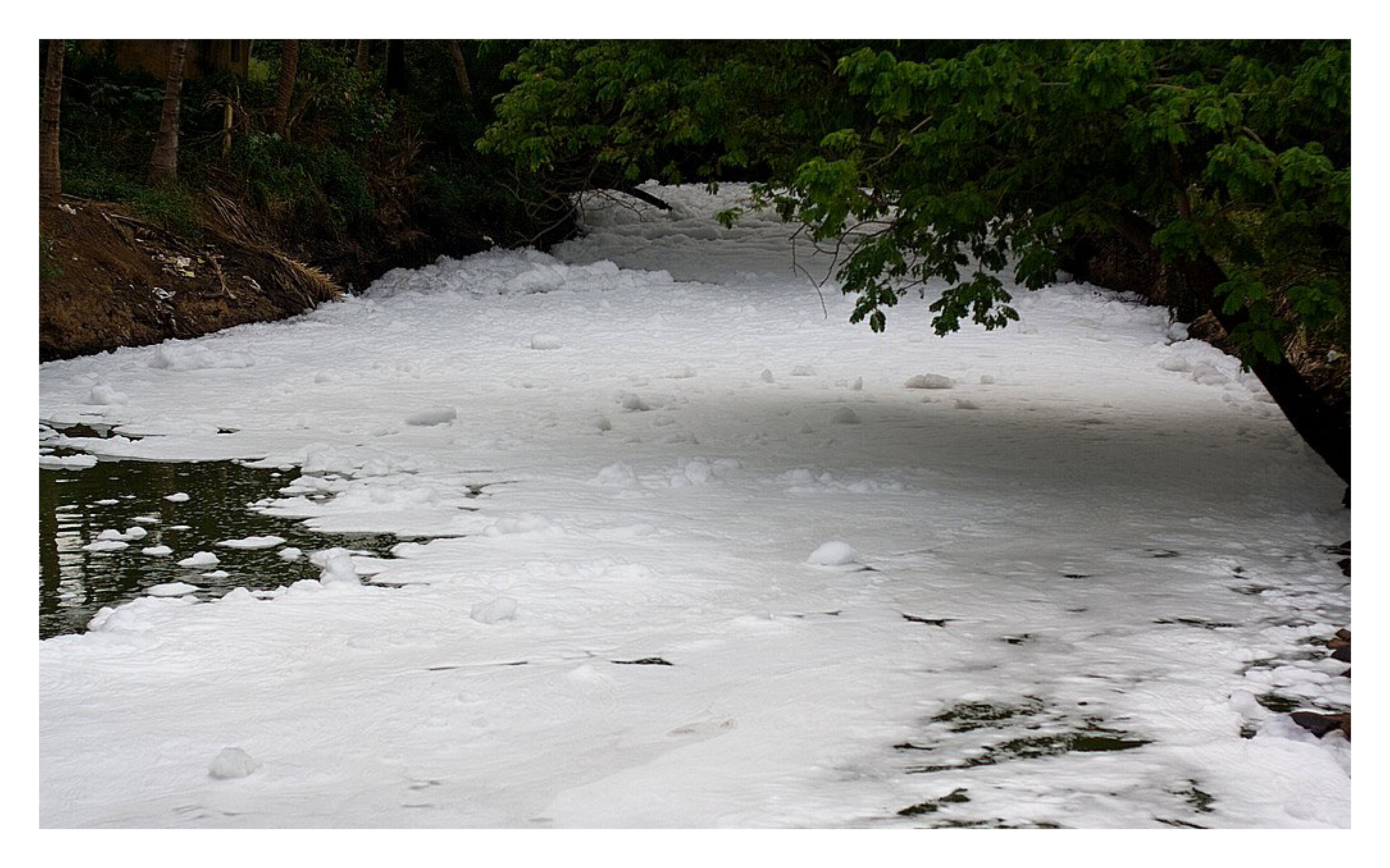
Lake polluted by industrial waste /Photo Source: "Bangalore Cleansing..." by Archer Ztudios is marked with CC BY-NC-ND 2.0
Construction and development has led to debris dumped in the area of the lake gives one an idea of the impunity that realtors enjoy. Construction material is overflowing even into the tank bund and drains of the area. Garbage is dumped near the lake and what is more, some even set fire to the garbage right there – unaware that burning non-biodegradable waste is a lose-lose situation. The mound of garbage has formed an uneven base on the lake over which vehicles have started moving from one point to another. Untreated sewage flows into the lake, turning the lake’s water black. This is the condition of just one lake near Electronics City. All around the industrial hub are other lakes, small and big. Close to the left edges of the sprawling area is the Shikaripalya Lake. This lake too has been violated to an extent that as of today a stench hangs in the area. Veerasandra Lake, meanwhile, is being choked to death by tall weeds that cover its surface and with authorities not bothering to clear it, hardly any water is visible in it.

Strained urban infrstructure / Photo Source: "Traffic jam" by Phillie Casablanca is marked with CC BY 2.0
Conclusion
Speculated impact of unregulated urbanization of the rural
By comparing urbanization in Chiloe and Bangalore - we see two contrasting scenarios where the former is undergoing the process of urbanization while the latter is highly urbanized and is claiming neighboring rural areas to continue densifying the peripheries of the city. We illustrate the conflict in the process of development and establish there is a need to take charge of the urban rural -transition in a sustainable and environmentally responsible manner.
While the literature identifies various social and economic consequences associated with urban sprawl and densification of the rural, this article focuses on environmental problems. These negative impacts include, among others, air pollution resulting from automobile dependency, water pollution caused in part by increases in impervious surfaces, the loss or disruption of environmentally sensitive areas, such as critical natural habitats (e.g., wetlands, wildlife corridors), reductions in open space, increased flood risks, and overall reductions in quality of life (Kenworthy & Laube, 1999; Hirschhorn, 2001; Kahn, 2000).
The problem of rapid spatial expansion in Bengaluru and Chiloe and other cities is an outcome of ineffective planning and inadequate land use policies. Therefore, in the present context, we need to arrive at an integrated and sustainable spatial planning that supports growth but at the same time protects the environment and its surrounding communities.