Har Homa: Exploring the Infrastructure(s) of an Israeli settlement
Introduction
We have chosen to look at the infrastructure(s) of Israeli settlements on the Palestinian Occupied Territories through a spatial exploration of the settlement of Har Homa (officially Homat Shmuel) just outside of Jerusalem. Building on a rich theoretical foundation and academic endeavours, we decided to continue the conversation of how Israel is using spatial practices to further its occupation of Palestinian lands through a visual case study. Har Homa stood out to us in several ways; first of all because of its proximity and de facto integration into Jerusalem’s wider urban fabric, second of all because its creation came about concurrently with the Oslo Peace Process, and third of all because it was built in part on Palestinian expropriated land. In addition to this, its development has continued since its construction in the latter half of the 1990s, and it has proved to be a continuing point of contention within the context of the Israeli-Palestinian conflict.
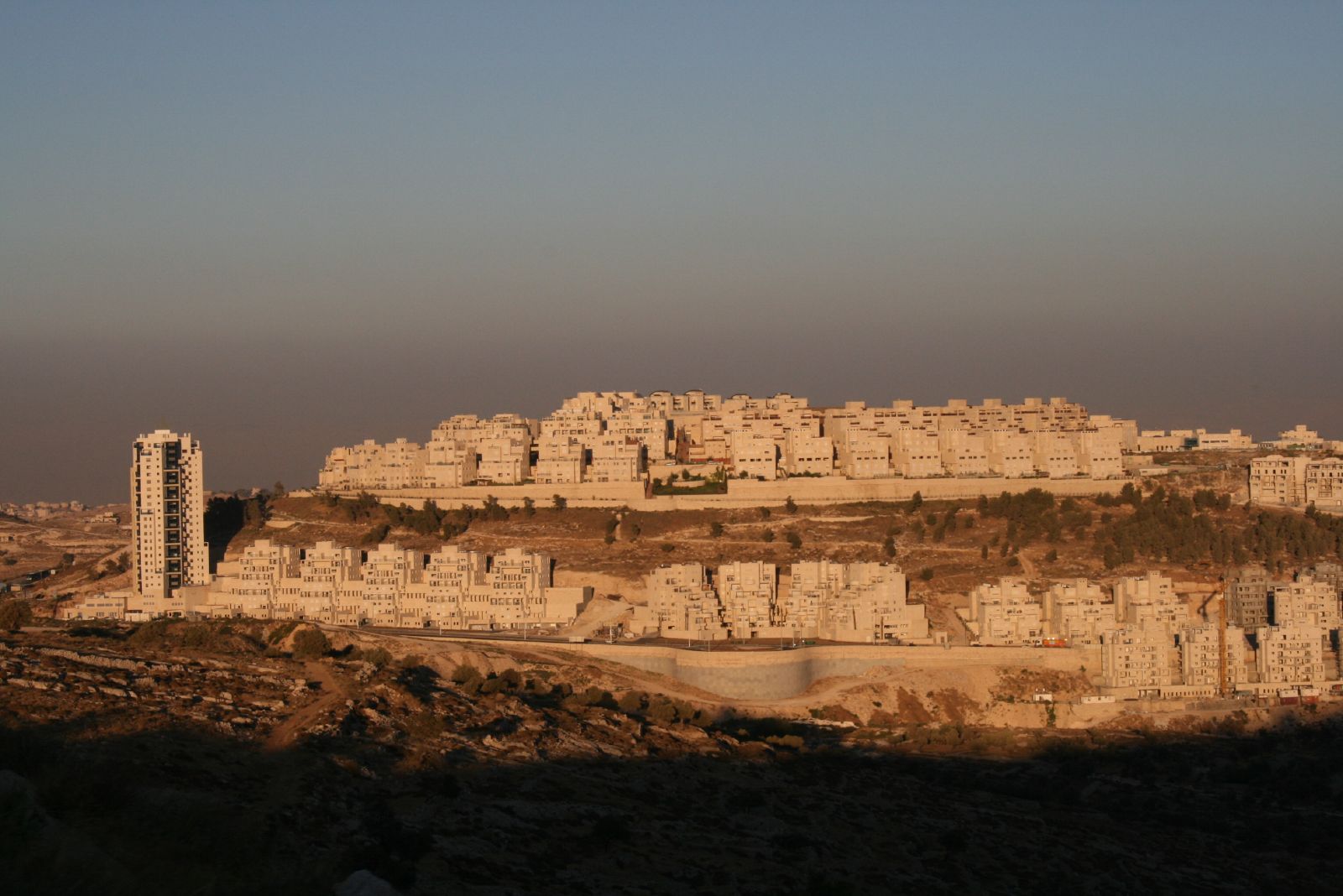 Har Homa
Background
Conceived by former Israeli Prime Minister Yitzhak Rabin in the first half of the 1990s (Rosen, 2012, p. 36), Har Homa is situated on a hilltop in the southern parts of East Jerusalem. For Palestinians, it is known as Jabal Abu Ghneim. As mentioned, the settlement was particularly controversial from its inception, owing in part to the fact that it in part was built on Palestinian expropriated land (Greenberg, 1997). Before construction of the Israeli settlement, Jabal Abu Ghneim was a ‘lonely, barren, and stony mountain’ surrounded ‘for kilometers to the east, west and south [by] more barren land, occasionally broken by other, smaller lonely mountains’ (Kaminker, 1997, p. 5). On February 19, 1997, Israel decided to proceed with the construction of Har Homa (Peace Monitor, 1997, p. 126). In 2003, the settlement had just over 2,000 inhabitants; at the end of 2016, over 20,000 settlers called Har Homa home (B’Tselem, 2019).
The settlement is neighbored to the north by two Palestinian neighborhoods, Umm Tuba and Sur Baher; on the south side by the Palestinian towns of Beit Jala, Bethlehem and Beit Sahour. Further away on its western side, Har Homa is neighbored by another Israeli settlement, Gilo; it was built on Palestinian land that was expropriated in 1970 (Kaminker, p. 6). On its northern side is the kibbutz Ramat Rachel, which was established in 1926 and, much like Har Homa, on a ‘prominent hilltop’ (Lipschits et al., 2011, p. 4). Once past Ramat Rachel, we effectively find ourselves in Jerusalem proper.
A short foray into the land use politics surrounding settlements and neighborhoods in Jerusalem is also necessary; large amounts of Palestinian-owned land are zoned as ‘open view’ land, meaning that nothing can be built on it (Kaminker, p. 9). Further, its size and location are ‘entirely arbitrary’, and it creates ‘large amounts of dead space that can easily be expropriated’ when needed (Kaminker, p. 9). This is what happened in the case of Har Homa. When Har Homa was planned and constructed in 1997, Israelis could build up to eight apartments on each dunam; Palestinians in neighboring Sur Baher could only build one or two (Kaminker, p. 10). These are just two examples of how Israeli land use policies and zoning continuously have favored the growth of Israeli urban centers over Palestinian ones, and how technocratic languages muddies the waters of what is in reality a systematic denying of the rights of Palestinians on their own land.
Historical Maps Overlay
As part of looking into the history of our site, we decided to analyze historical maps. Our main source for this comparison was the online platform Palestine Open Maps. Figure 1 shows an animated layering of the available maps for our site, with material ranging from a 1879 British map to contemporary satellite imagery. The comparative study of the maps reveals how the de facto ownership and occupation of the land changed over the course of 150 years. For every new map, we describe the content and the discrepancy of information between the various sets of cartographic data.
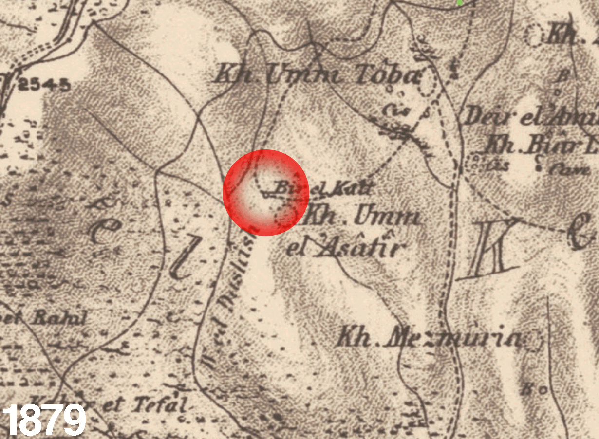
1879 Map
This document is a British map issued by the Palestine Exploration Fund, a semi-secular society based in London, whose topographic and ethnographic surveys of Ottoman Palestine served as a hybrid of military intelligence information-base and exploratory research (Howe, 1997, p. 37). By examining the document we find that the settlement of Har Homa lies where the inscriptions “Bir El Katt” and below, slightly larger, “Kh. Umm el’Asâtir” are. A circled dashed line perimeter that indicates a pocket of settled population can be seen next to these annotations. Additionally, we find that the multiple black lines surrounding the site stand for the desiccated streams of the region - the legend of the map (see Fig.1) notes “Single black lines represent dry water courses except where aqueduct is written.”
The term “Kh.” stands for “khirbet” - “ruin of” in Arabic. “Bir El Katt” instead stands for “the well of the crag” according to the 1888 Palestine Exploration Fund’s general index of the Survey of Western Palestine. [see Fig.2] It is unclear whether in 1879 this site was occupied, but the presence of well does suggest this.
1943 Map
This map was produced for the Survey of Palestine, in the context of the 1946 Anglo-American Committee of Inquiry; a joint British and American commission set up to provide guidance on the introduction of 100,000 Holocaust survivors (as suggested by the 1945 Harrison report) on British-ruled Palestinian territory. This is the map that features the most extensive data set in the Palestine Open Maps repertoire. It provides urban, agricultural, infrastructural, topographic, as well as fine-grained architectural information. New particulars regarding our site are:
- the type of sediments surrounding the hill, indicated as ‘cropping rocks’ in the legend.
- the types of vegetation on the western and north-eastern edges of the site, indicated as ‘o’ and ‘ol’ (for orchard and olive grove).
- the existence of a water pipe line, southeast of the hill.
- the existence of a cistern, north of the hill.
- the existence of three lime kilns, east and north of the hill.
- a network of roads north of the site towards the Palestinian neighbourhood of Sur Baher and Jerusalem.
- a north-south track along the western side of the hill, followed by a track towards Ramat Rachel and consequently towards Jerusalem.
- a north-east to south-west track on the south-eastern portion of the site.
The top of the hill features a black rectangle, which represents an ‘isolated building’, and a perimetric thin black line, which represents a ‘wall, fence, hedge, canal, etc.’. Beneath these marks lies the inscription ‘Jebel Abū Ghunneim’ - the arabic name of the mount. On the basis of this, we may conclude that there is sufficient evidence to claim that in 1943 the site was occupied by some kind of settled Palestinian population.
1944 Map
This document is another map for the Survey of Palestine, however its information is significantly reduced compared to the 1943 map. Here, the main highlights are the topographic contour lines, information regarding vegetation, the two paths around the hill and the indication of archeological sites (the ‘Khirbats and abandoned sites’). A dot at the top of the hill indicates the presence of a cistern.
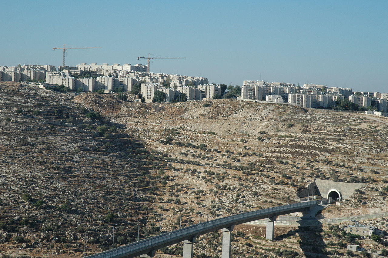
2019 Satellite image
Finally, this up to date image of the site reveals the radically altered, and henceforth inherently urban, scenario of the hill. The picture shows a highly-developed network of internal roads and buildings. The settlement is, however, a closed loop onto itself and remains isolated owing to the fact that it only has one entry/exit route (located north-west of the hill, in the direction of Jerusalem).
This cartographic comparison provides an important historical backdrop to our inquiry, establishing a clear timeline as well as firmly establishing evidence for the sequence of events.
Academic conversation & theoretical underpinnings
Long-standing Israeli urban planning doctrines come together in the case of Har Homa; both the idea of building on hilltops, the principle of ‘optical urbanism’, and a preoccupation with the rural and the periphery. The workers’ moshav of Nahalal, founded in the 1920s, provides an important precedent in terms of form: the ‘perfectly oval scheme’ of the moshav is ‘an image at once hermetic, panoptic and defensive, while radiating outward and drawing in the landscape; a totalizing structure that consecrates the cohesive community’ (Efrat, 2018, p. 33). In the context of 1920s Mandatory Palestine and its Jewish population, this kind of building was predominantly made on the plains of what today is Israel; the 1970s West Bank settlement project which largely started in the 1970s, on the other hand, has been argued to be the ‘culmination of Zionism’s journey from the plains to the hills’ - a ‘topographical migration’ (Segal & Weizman, 2003, p. 80-81).
As Segal & Weizman argues, following the Israeli occupation of the West Bank in 1967, its ‘mountain peaks [and barren hilltops] easily lent themselves to state seizure’ - with the ensuing urban typology of these mountain settlements being characterized by a ‘principle of concentric organization in which the topographical contours of the map are retraced as lines of infrastructure’, with ‘roads […] laid out in rings around the summit with the water, sewage, electricity and telephone lines buried under them’ (Segal & Weizman, p. 82-83). The idea put forward here is that these mountain settlements, of which Har Homa is a schoolbook example, rather than being ‘exhibits of ordered forms’ actually are ‘manifestations of anti-forms, the end results of tactical, land-use and topographical constraints (Segal & Weizman, p. 83). There is also the double nature of these settlements: they are ‘not only places of residence, but [also] create a large-scale network of ‘civilian fortifications’’; the outward oriented gaze of the settlement ‘surveys the landscape around it’ (Segal & Weizman, p. 84-85).
 Highway 60 near Har Homa
In addition to the theories of optical urbanism and hilltop settlements as put forward by Segal and Weizman, we also rely on theories around infrastructure, notably Larkin’s ideas on infrastructure as operating on several levels concurrently (Larkin, 2013, p. 335-336), and linked to this the idea of ‘doubling’ of infrastructure. As Larkin notes, infrastructures ‘execute technical functions […] by mediating exchange over distance and binding people and things into complex heterogeneous systems and by operating as entextualized forms that have relative autonomy form their technical function’, by which a rearrangement of the ‘hierarchy of functions’ occurs ‘so that the aesthetic dimension (rather than its technical one) is dominant. In the case of the infrastructure(s) of Israeli settlements, and in the case of Har Homa, we can clearly see how they serve several purposes, and where the purposes of them can be variably masked and unmasked, and how often the line between is blurred to the point of obscurity.
It is within these theoretical debates and academic forays into Israeli hilltop settlements that we wish to add to the conversation by providing a spatialized version of a settlement in an effort to expand on the work that has come before us. Recognizing the density of material written about this topic, we seek to focus on the combination of theory and spatial representation as a way to move the conversation forward and create new spaces for exploration and debate.
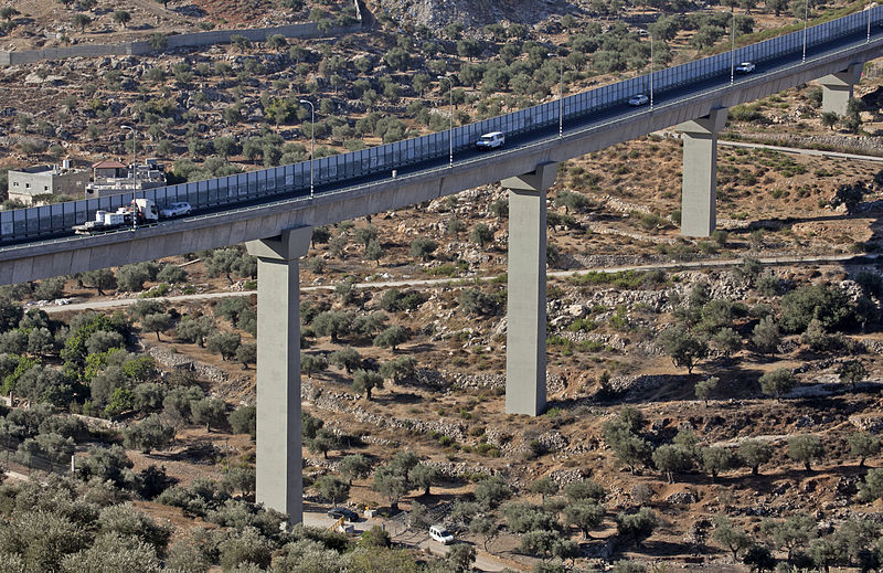 Highway 60 near Har Homa
Methodology
Our approach to representation focused on moving imagery as a rhetorical tool. Due to the lack of an existing topographical model we could base our work on, we produced a digital file based on various archival maps & online sources. We extracted topographic contours and combined them in a hierarchy system based on each resource’s most up-to-date data. A GIS data-set supplemented this model with infrastructural information such as highways, bus stops and buildings geolocation. The resulting model allows us to shift between various layers of information and different scales. Colour-coding is used as a way of conveying information in the overall highly-abstracted representational realm of the animation.
The animation takes the viewer through three principal scales: national (with highways and borders), regional (with neighbourhoods surrounding Har Homa and the topography) and finally, local (with existing transport infrastructure and the settlement’s urban and architectural configuration).
Rhino served as the primary topological modelling software. Contour lines at intervals of 10ft of altitude were drawn and lofted together. GIS layers of data were then projected onto the meshes and extruded according to buildings heights, or in case of bus stops, an arbitrary visible height. 3DsMax was used to refine the images of the ground through displacement, bump and refraction maps, and the entire animation was rendered through V-ray.
Spatialization
The video above shows the finished visualization. It shows a gradual zoom-in from the national scale down to Har Homa, putting the singular hilltop settlement just outside of Jerusalem proper in a larger national context. It highlights the ways in which Israel has deployed functions of bypass urbanism and the doubling of infrastructure inherent in the Israeli settlement endeavor.
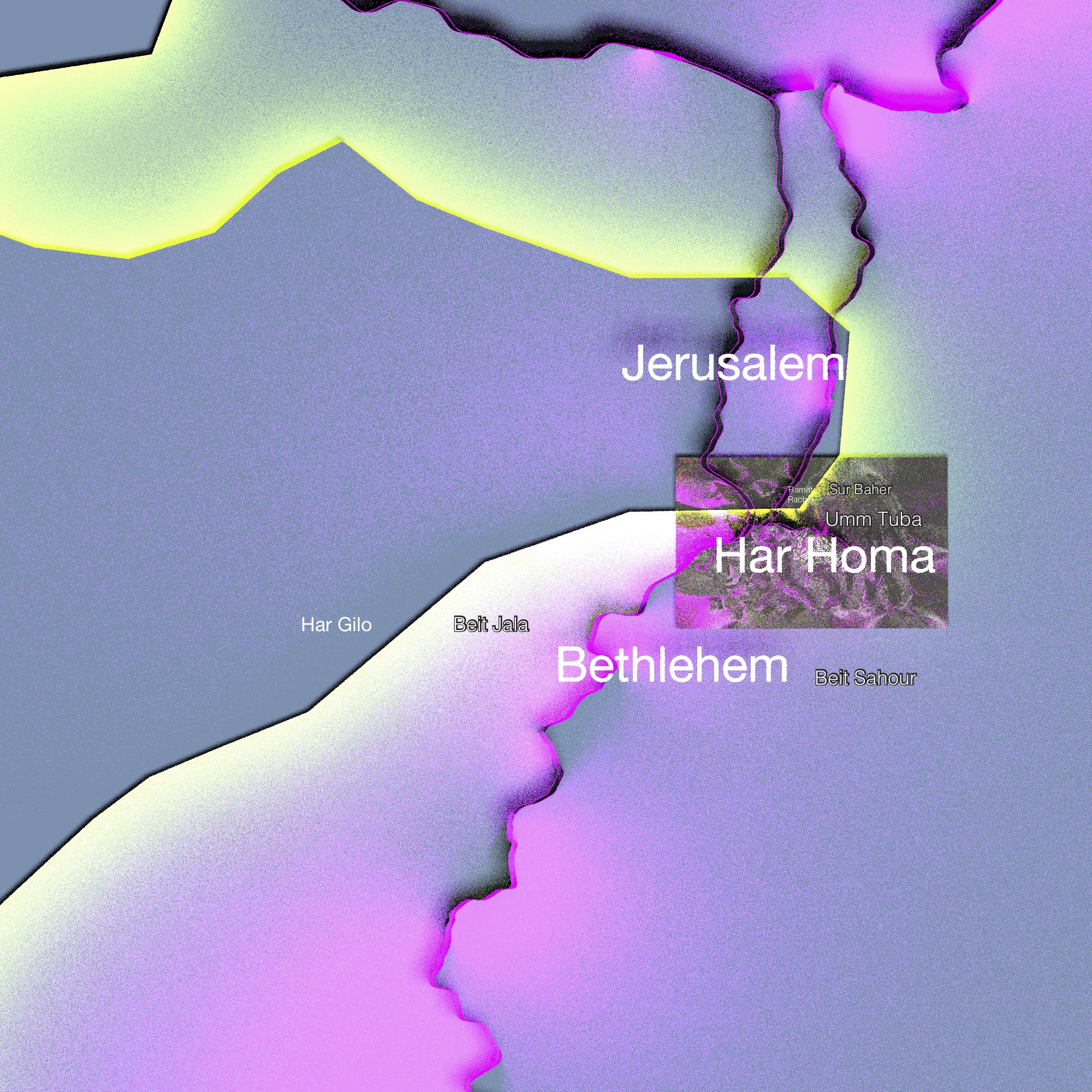 Har Homa in the context of greater Jerusalem, with highways highlighted in pink, and the West Bank border in yellow
Within the urban fabric of Jerusalem and its suburban settlements, Har Homa is effectively an Israeli enclave surrounded by Palestinian towns and neighborhoods. With regard to function, however, Har Homa is connected via highways to other parts of Israel, as well as to other settlements via Highway 60; effectively entirely bypassing Palestine and along with its urban fabric.
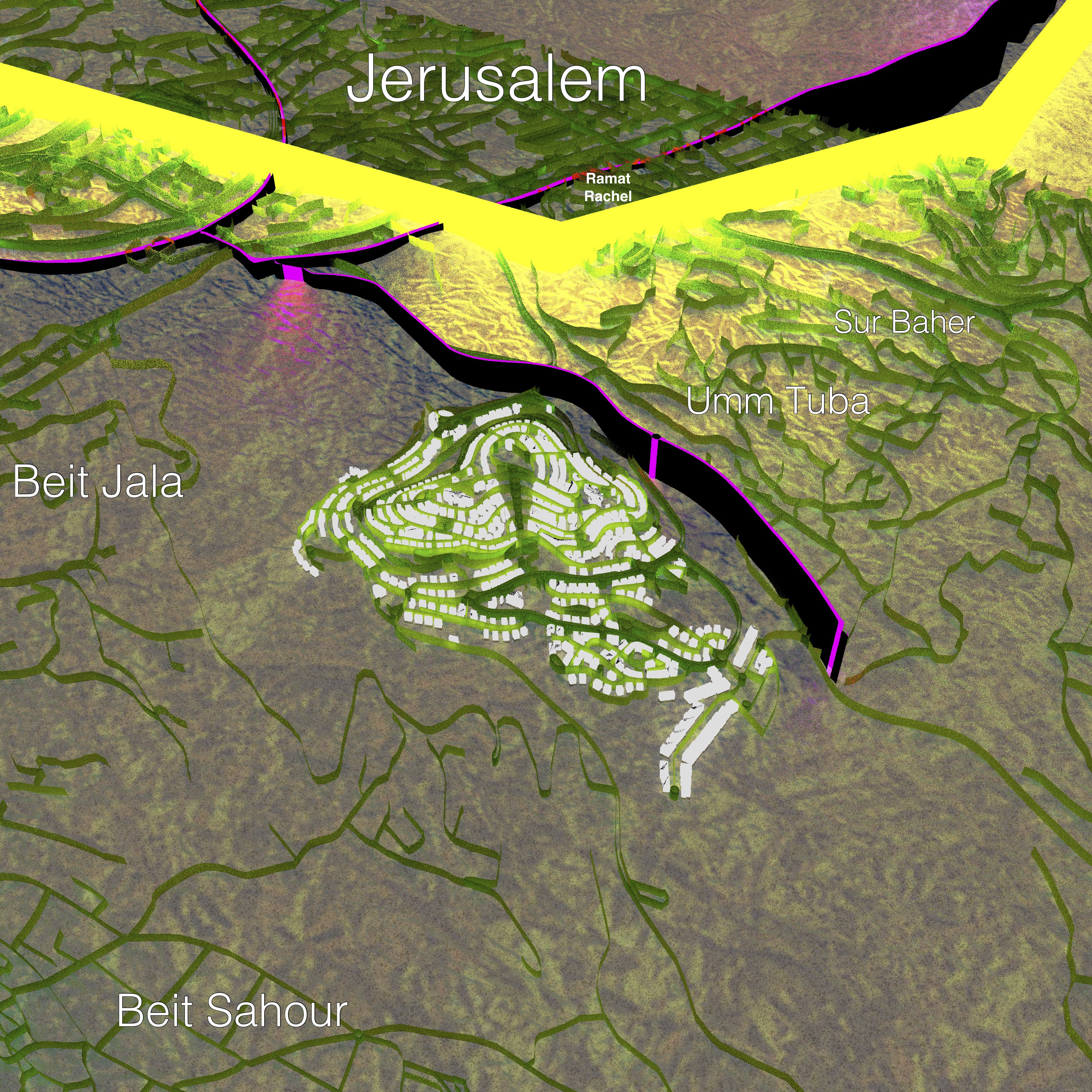 Topography and building print of Har Homa
Har Homa is built atop the Palestinian hilltop of Jabal Abu Ghneim - exemplifying the Israeli urban planning practice of optical urbanism transplanted onto the hilly portions of the occupied West Bank. Here, Jabal Abu Ghneim stands out as a particularly suitable object for this Israeli doctrine, offering a clearly defined landmass, and one that is clearly defined in the topography - offering one of the defining features of optical urbanism: outward surveillance. As explained earlier, the topography of the hill is the defining feature in the overall design of the settlement, and its lines become the very mechanisms of Har Homa’s defensive layout.
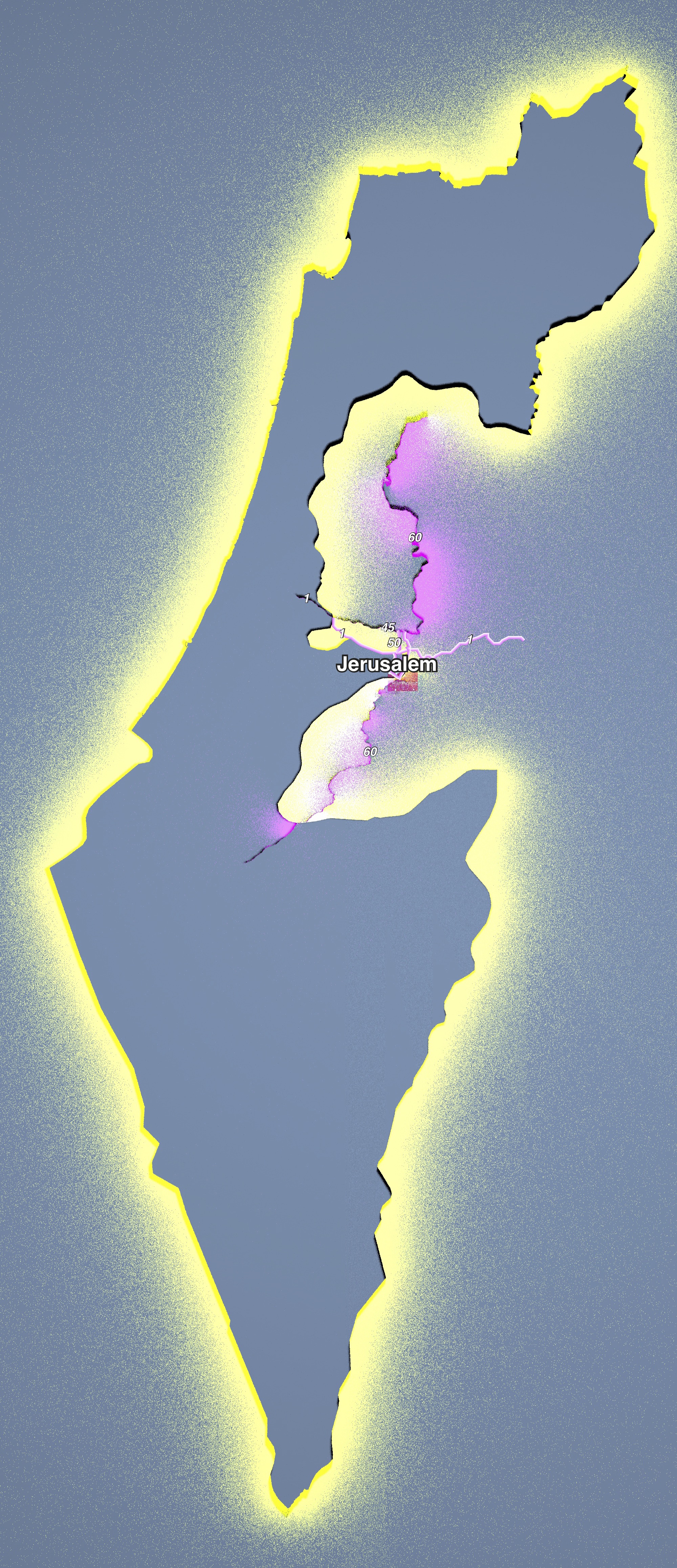 Jerusalem and Har Homa on the national scale, highlighting highway connections
Har Homa is connected via a range of highways to the rest of Israel, as well as to the rest of the occupied West Bank. Highway 60 binds together Israeli settlements on the West Bank from north to south; Highway 1 links the northernmost part of the Dead City with Tel Aviv, constituting Israel’s defining east-west connection; a few other highway portions operate in the cluster in and around Jerusalem to aid these two main connections, as well as a range of other main roads spidering out into Israel and the Occupied Palestininan Territories. This imagery makes it clear how Har Homa is connected through these highways to other Israeli settlements and Israeli cities in a way it is not to even its neighboring Palestinian towns and neighborhoods. The notion of speed is important here as well: inherent in the idea of a highway is the ability to bypass points of lesser interest. In the design of the Israeli highway system in the Occupied Territories, Palestinian towns are by design bypassed and deemed less relevant, less important.
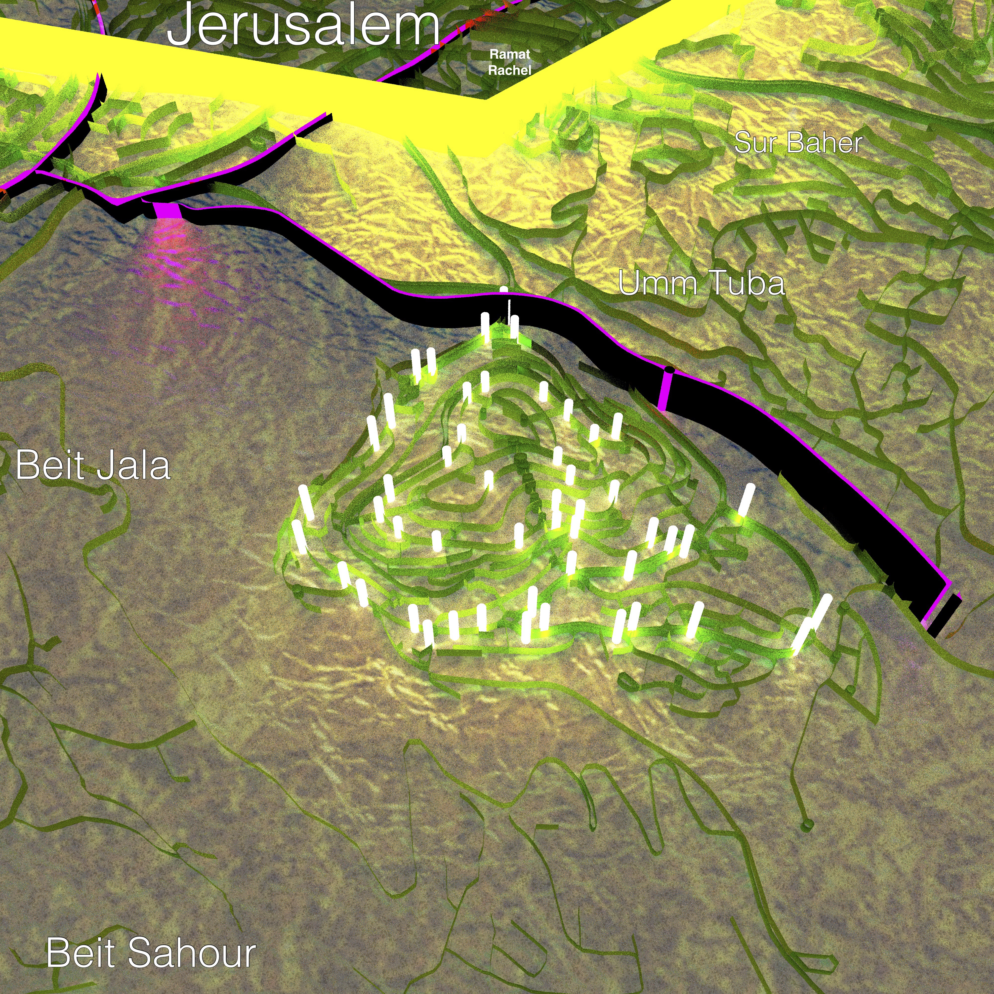 Har Homa’s bus stops
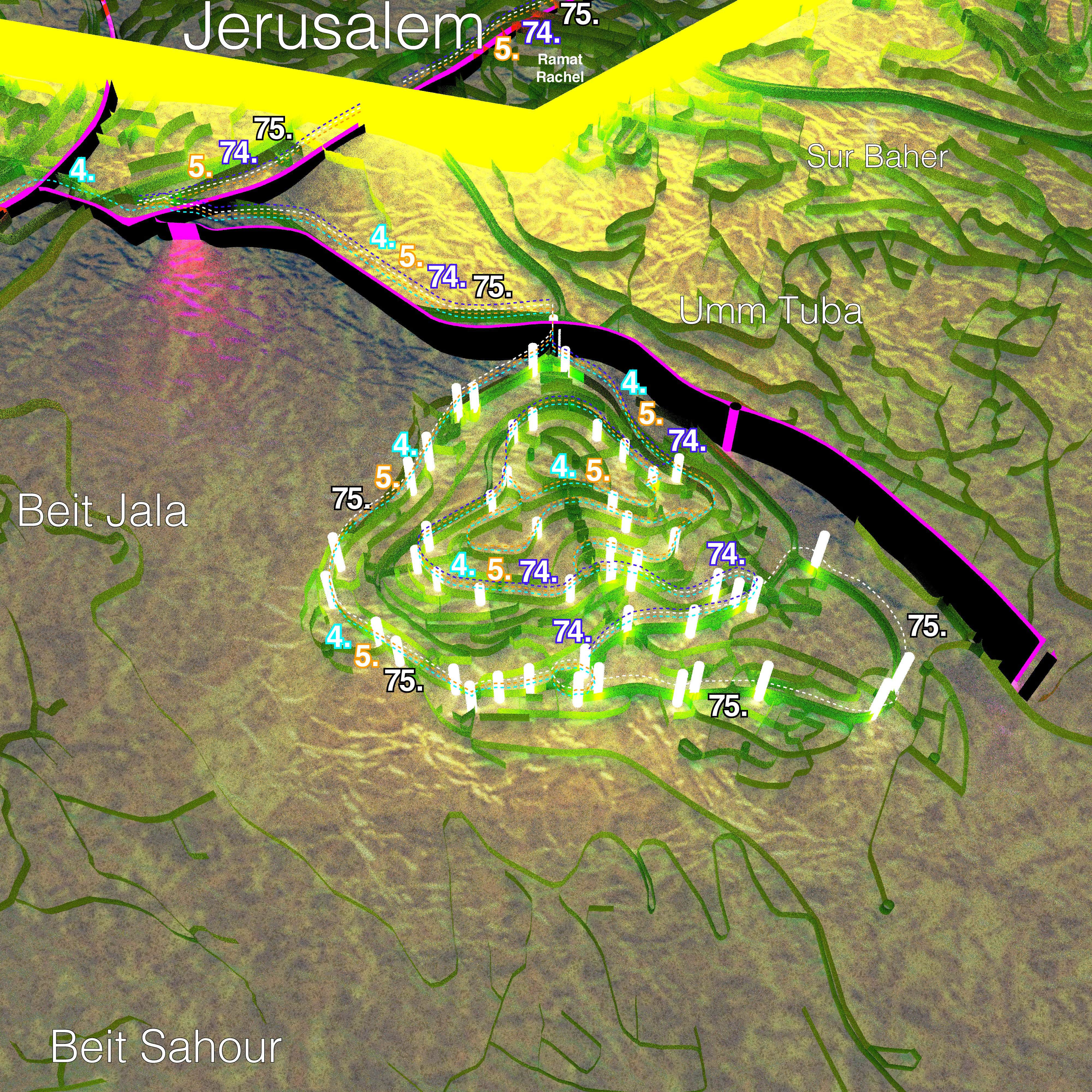 Bus stops with added line numbers
Public transport offers the final lens through which we were able to look at infrastructure in this context; Har Homa is dotted with bus stops - all of them connecting the settlement with a range of links to West Jerusalem. Not one of them provides a link to East Jerusalem. Just by the very design of the bus routes, the way in which Palestinian neighborhoods and towns are bypassed is heavily intensified.
Conclusion
Through exploring the infrastructure(s) of Har Homa, building on existing academic work - notably by Segal and Weizman, we have sought to add to this already rich literature on Israeli settlement in the Occupied Palestinian Territories through a work of spatialization and visualization. Through our visualization, we have been able to show ways in which Israeli urban planning politics further the dynamics of Israeli occupation; tackling the topic from a more visual point of view that has been done before. Through looking at highways, public transport infrastructure, as well as the street grid and building patterns of Har Homa, these practices by the Israeli government have become even more evident.
References
B’Tselem - The Israeli Information Center for Human Rights in the Occupied Territories. (2019). Statistics on Settlements and Settler Population. Retrieved from: https://www.btselem.org/settlements/statistics
DIVA-GIS. (2020). Administrative areas (GADM), Israel. Retrieved from: http://www.diva-gis.org/
Efrat, Z. (2018). The Object of Zionism. Leipzig: Spector Books.
Howe, K. (1997). Revealing the Holy Land : the photographic exploration of Palestine. Santa Barbara, CA: University of California Press, 37.
The Humanitarian Data Exchange. (2020). State of Palestine - Oslo Agreement in the West Bank. Retrieved from: https://data.humdata.org/dataset/state-of-palestine-other-0-0-0-0-0
Institute for Palestine Studies. (1997). Peace Monitor: 16 February-15 May 1997, Journal of Palestine Studies, 26(4), pp. 126-137
Kaminker, S. (1997). For Arabs Only: Building Restrictions in East Jerusalem, Journal of Palestine Studies, 26(4), pp. 5-16
Larkin, B. (2013). The Politics and Poetics of Infrastructure, Annual Review of Anthropology, (42), pp. 327-343
Lipschits, O., Gadot, Y., Arubas, B. & Oeming, M. (2011). Palace and Village, Paradise and Oblivion: Unraveling the Riddles of Ramat Rahel, Near Eastern Archaeology, 74(1), pp. 1-49
Masferrer Pascual, M. (2007). Har Homa. Retrieved from: https://commons.wikimedia.org/wiki/File:Har_Homa.jpg
McIntosh, J. (2004). Tunnel to Gush Etzion. Retrieved from: https://commons.wikimedia.org/wiki/File:Tunnel_to_Gush_Etzion.jpg
OpenStreetMap data. (2020). © OpenStreetMap contributors. Licence: <www.openstreetmap.org/copyright>
The Palestine Exploration Fund. (1888). The Survey of Western Palestine - A General Index. London: Harrison & Sons, 86.
Palestine Open Maps. Retrieved from: https://palopenmaps.org/view
Segal, R. & Weizman, E. (2003). A Civilian Occupation: The Politics of Israeli Architecture. Verso Books.
Rosen, S. J. (2012). Israeli Settlements, American Pressure, and Peace, Jewish Political Studies Review, 24(1/2), pp. 32-44
zeevveez. (2014). Bridge that Unites with a Wall that Separates. Retrieved from: https://www.flickr.com/photos/29001414@N00/15173489876